- Table View
- List View
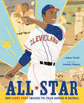
All Star: How Larry Doby Smashed the Color Barrier in Baseball
by Audrey VernickThe remarkable story of Larry Doby, the first Black baseball player in the American League. In 1947, Larry Doby signed with the Cleveland Indians, becoming the first Black player in the American leagues. He endured terrible racism, both from fans and his fellow teammates. Despite this, he became a unifying force on and off the field, and went on to become a seven-time All Star. Illustrated with Cannaday Chapman&’s bold, stylized illustrations, this exceptional biography tells the story of an unsung hero who not only opened doors for those behind him, but set amazing records during his Hall of Fame career. More significantly, it examines the long fight to overcome racism in sports and our culture at large, a fight that is far from over.
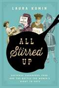
All Stirred Up: Suffrage Cookbooks, Food, and the Battle for Women's Right to Vote
by Laura KuminIn honor of the centenary of the 19th amendment, a delectable new book that reveals a new side to the history of the suf frage movement.We all likely conjure up a similar image of the women&’s suffrage movement: picket signs, red carnations, militant marches through the streets. But was it only these rallies that gained women the exposure and power that led them to the vote? Ever courageous and creative, suffragists also carried their radical message into America&’s homes wrapped in food wisdom, through cookbooks, which ingenuously packaged political strategy into already existent social communities. These cookbooks gave suffragists a chance to reach out to women on their own terms, in nonthreatening and accessible ways. Cooking together, feeding people, and using social situations to put people at ease were pioneering grassroots tactics that leveraged the domestic knowledge these women already had, feeding spoonfuls of suffrage to communities through unexpected and unassuming channels. Kumin, the author of The Hamilton Cookbook, expands this forgotten history, she shows us that, in spite of massive opposition, these women brilliantly wove charm and wit into their message. Filled with actual historic recipes (&“mix the crust with tact and velvet gloves, using no sarcasm, especially with the upper crust&”) that evoke the spirited flavor of feminism and food movements, All Stirred Up re-activates the taste of an era and carries us back through time. Kumin shows that these suffragettes were far from the militant, stern caricatures their detractors made them out to be. Long before they had the vote, women enfranchised themselves through the subversive and savvy power of the palate.
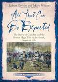
All That Can Be Expected: The Battle of Camden and the British High Tide in the South, August 16, 1780 (Emerging Revolutionary War Series)
by Mark Wilcox Robert OrrisonA history and analysis of the 1780 South Carolina battle that marked the turning point for Great Britain in the American Revolutionary War. “An impressive work of collaborative historical research by historians Robert Orrison and Mark Wilcox, this is the newest title in the simply outstanding ‘Emerging Revolutionary War’ series from Savas Beatie and a welcome, unreservedly recommended pick.”—Midwest Book Review “They have done all that can be expected of them, we are outnumbered and outflanked,” explained Lt. Col. Benjamin Ford regarding the desperate situation his Marylanders faced on the disastrous day of August 16, 1780.Many historians consider the battle of Camden as the high tide of Great Britain’s prospects for victory in the American South. In the spring of 1780, British leadership focused their attention on conquering the Southern Colonies. Charleston capitulated, along with the bulk of the American army defending it, in May of 1780. After its fall, the British set up outposts across South Carolina’s backcountry to secure that colony before moving into North Carolina. In response, the Continental Congress sent Gen. Horatio Gates, the “hero of Saratoga,” to take over the Southern Department. Gates reorganized the forces there and named his field command “Grand Army,” whose core was a small contingent of experienced Continentals from Maryland and Delaware. The majority, however, was comprised of untested soldiers and newly recruited militia from Virginia and North Carolina. Soon after his arrival, Gates led his army south to confront the British near Camden, South Carolina. The mostly inexperienced American force found itself facing some of the best units of the British army under the command of one of its best generals, Charles Cornwallis. The result was an unmitigated disaster for the Americans with far-reaching consequences.In All That Can Be Expected: The Battle of Camden and the British High Tide in the South, August 16, 1780, historians Rob Orrison and Mark Wilcox set forth the events surrounding one of the worst American military defeats in United States history. Readers will also follow in the footsteps of American and British soldiers through the South Carolina backcountry on a narrative tour to help better understand this fascinating campaign of August 1780.
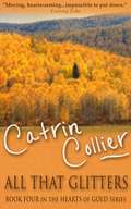
All That Glitters
by Catrin CollierCornish smuggler Devlin 'Devil' Varcoe braves winter weather and revenue men to fetch the contraband on which Porthinnis depends for survival. Drawn to Jenefer Trevanion, whose father finances the smuggling operation, Devlin is seduced by beautiful wild-child Tamara Gillis. When fire destroys her home, Jenefer is forced to work in the pilchard cellars. Meanwhile, craving Tamara for himself, Thomas Varcoe plots murder to rid himself of the brother he hates. Rejected by Devlin, a pregnant Tamara is pressured to marry Thomas. Finally recognising the love he never felt he deserved, Devlin is on his way home after successfully undertaking a secret mission when a once-in-a-lifetime storm faces him with a terrible choice.
All That Glitters
by John Gapper Nicholas DentonThe definitive, classic account of the fall of the House of Baring, the oldest merchant bank in London, in 1995 and the ultimate rogue trader, Nick Leeson, who brought down the venerable institution with speculative investing. John Gapper, associate editor of the Financial Times, and his coauthor Nicholas Denton, now founder of Gawker Media, interviewed all the major players involved in the collapse of one of England's oldest banks. All That Glitters reveals the Faustian deal struck between the whizz-kid derivatives traders who seemed to be bringing in huge profits and the old guard who were happy to pocket them without asking too many questions. Gapper and Denton present a thrilling, in-depth account of Nick Leeson's motives and methods for hiding the unauthorized speculative trading as well as the final days of Barings and the last-ditch attempts by politicians and bankers to save the bank.
All That Glitters
by Michael MurphyIn Michael Murphy's rollicking new Jake & Laura mystery, the hard-boiled writer and the aspiring movie star head for sun-drenched Los Angeles, where a cold-blooded murderer lurks behind the scenes. Just arrived from New York, Broadway actress Laura Wilson is slated to star in Hollywood's newest screwball comedy. At her side, of course, is Jake Donovan, under pressure to write his next mystery novel. But peace and quiet are not to be had when an all-too-real murder plot intrudes: After a glitzy party, the son of a studio honcho is discovered dead from a gunshot wound. And since Jake exchanged words with the hothead just hours before his death, the bestselling author becomes the LAPD's prime suspect. In 1930s Tinseltown, anything goes. Proving his innocence won't be easy in a town where sex, seduction, and naked power run rampant. With gossip columnist Louella Parsons dead-set on publicizing the charges against him, Jake has no choice but to do what everyone else does in the City of Angels: act like someone else. Blackie Doyle, the tough-talking, fist-swinging, womanizing hero from Jake's novels wouldn't pull any punches until he exposed the real killer--nor will Jake, to keep the role of a lifetime from being his last.Praise for All That Glitters "Jake and Laura really do remind me of Dashiell Hammett's Nick and Nora Charles. They are fun, witty, and charming, and the novel is filled with the same kind of 1930s Hollywood glamour that made the film of The Thin Man such a classic."--Popcorn Reads "Art imitates life imitates art imitates life, with just as terrific results as the first book in this series, The Yankee Club."--Reading Reality "Michael Murphy has pulled off another successful novel with interesting characters, a riveting story, and a great setting that transports us back to Prohibition-era Hollywood."--The Book Binder's Daughter "Murphy has a good thing going with this great new historical mystery series. . . . [They're] fast-paced and a good look back at an interesting era and the people in it."--Joyfully Retired "Highly entertaining . . . Mystery lovers, noir fans and lovers of classic movies will really go for this book."--The Reader's Hollow "I couldn't put this book down. It grabbed me right from the start and I was quickly invested in the characters and their lives. . . . A great read and wonderfully fun characters."--Mystery Playground "You know how it is when you have the perfect cup? The aroma is great, the perfect balance in taste, it's hot enough to warm your soul, but not too hot to burn your tongue, and the mug fits perfectly in your hands. All the senses are engaged and you forget the world around you. That is this book to a mystery reader- it has the impeccable balance."--Lilac Reviews
All That Glitters (Enchantée #1)
by Gita TreleaseOriginally published as Enchantée, All That Glitters is Gita Trelease’s debut fantasy about an orphaned girl who uses dark magic to save her sister and herself is “a soaring success” (NPR)!Paris is a labyrinth of twisted streets filled with beggars and thieves, revolutionaries and magicians. Camille Durbonne is one of them. She wishes she weren’t...When smallpox kills her parents, Camille must find a way to provide for her younger sister while managing her volatile brother. Relying on magic, Camille painstakingly transforms scraps of metal into money to buy food and medicine they need. But when the coins won’t hold their shape and her brother disappears with the family’s savings, Camille pursues a richer, more dangerous mark: the glittering court of Louis XVI and Marie Antoinette.Using dark magic forbidden by her mother, Camille transforms herself into a baroness and is swept up into life at the Palace of Versailles, where aristocrats both fear and hunger for magic. As she struggles to reconcile her resentment of the rich with the allure of glamour and excess, Camille meets a handsome young inventor, and begins to believe that love and liberty may both be possible.But magic has its costs, and soon Camille loses control of her secrets. And when revolution erupts, Camille must choose—love or loyalty, democracy or aristocracy, reality or magic—before Paris burns.
All That Glitters: A Novel
by Thomas TryonThe interlocking lives of five Hollywood leading ladies spawn &“tragedies, dark doings, jealousies, murder, passion on the grand scale&” (Chicago Tribune). Charlie Caine has been to too many Hollywood funerals. The studio system is long gone, and its stars—some forgotten, some preserved for display on a late-night show—are beginning to pass on, as well. Only a few turn out for the final performance of Babe Austrian, a peroxide-blond beauty whose red-hot talkies changed the way America thought about sex. As he gazes into her coffin, Caine remembers Babe as she was: a dynamite beauty with secrets that could have burned Hollywood to the ground. In Babe and four other interlocking novellas, Caine recalls the leading ladies of long-lost Hollywood: Belinda, whose daughter was as cruel as she was lovely; Claire, who would do anything to stay in the public eye; April, fragile, beautiful, and mad; and Maude, Hollywood&’s most respected matron, whose happy marriage had a lie at its heart. Charlie Caine knows where cinema&’s bodies are buried, and he&’s anxious to start digging.
All That Glitters: A Story of Friendship, Fraud and Fine Art: A Guardian and FT Book to Read in 2024
by Orlando Whitfield'One of the hottest memoirs of 2024' Sunday Times StyleA Guardian 'Books to look out for in 2024' pick * A Financial Times 'What to Read in 2024' pick'An art world Great Gatsby, deliciously withering and dishy.' Patrick Radden Keefe'Delicious, sharp and often breathtaking' Megan Nolan'A brilliant, devastating exposé' William BoydDECEPTION IS A FINE ART.When Orlando Whitfield first meets Inigo Philbrick, they are students dreaming of dealing art for a living. Their friendship lasts for fifteen years until one day, Inigo - by then the most successful dealer of his generation - disappears, accused of a fraud so gigantic and audacious it rocks the art world to its core.A sparklingly sharp memoir of greed, ambition and madness, All That Glitters will take you to the heart of the contemporary art world, a place wilder and wealthier than you could ever imagine.
All That Glitters: A Story of Friendship, Fraud, and Fine Art
by Orlando WhitfieldA NEW YORKER, ECONOMIST, AND TOWN & COUNTRY BEST BOOK OF THE YEAR • A dazzling insider&’s account of the contemporary art world and the stunning rise and fall of the charismatic American art dealer Inigo Philbrick, as seen through the eyes of his friend and fellow dealerIn development as a series for HBOOrlando Whitfield and Inigo Philbrick met in 2006 at London&’s Goldsmiths University where they became best friends. By 2007 they had started I&O Fine Art.Orlando would eventually set up his own gallery and watch as Inigo quickly immersed himself in a world of private jets and multimillion-dollar deals for major clients. Inigo seemed brilliant, but underneath the extravagant façade, his complicated financial schemes were unraveling. With debt, lawsuits, and court summonses piling up, Inigo went into a tailspin of lies and subterfuge. At around the same time, Orlando would himself experience a nervous breakdown and leave the art world for good. By 2019 things had spiraled enough out of control for Inigo to flee to the remote island nation of Vanuatu, 300 miles west of Fiji. Within a year, he was arrested by the FBI and extradited to America, where he was sentenced to seven years in prison for having committed more than $86 million in fraud. All That Glitters is at once a shocking and compulsive story of ambition and downfall, a cautionary tale, and an intimate portrait of friendship and its loss.
All That Glitters: Anna Wintour, Tina Brown, and the Rivalry Inside America's Richest Media Empire
by Thomas MaierFrom the Bestselling Author and Television Producer of Masters of Sex, a True Story ofthe Intrigue and Infighting of Condé Nast, Anna Wintour, S. I. Newhouse Jr., and Tina Brown, and Optioned by Sony Television Productions Inside the Condé Nast magazine world run by billionaire S. I. Newhouse Jr., Anna Wintour and Tina Brown were bold and talented British women who fought their way to the top of this male-dominated American industry driven by greed and betrayal. Wintour became an icon of fashion and New York’s high society, while Brown helped define the intersection of literary culture and Hollywood celebrity. They jockeyed for power in the hypercompetitive “off with their heads” atmosphere set up by Newhouse and his longtime creative guru Alex Liberman, two men who for years controlled the glossy Condé Nast magazines that dictated how women should look, dress, and feel. In turning this world upside down, Wintour and Brown challenged the old rules and made Newhouse’s company internationally famous. Ultimately, one of them won in their fascinating struggle for fame and fortune during the height of New York’s gilded age of print—a time before the internet, before 9/11, when the Reagans ruled the White House and Donald Trump was a mere local developer featured on the cover of Newhouse’s publications. This book traces the careers of Wintour and Brown and shows how they and the Condé Nast media empire were major media enablers in the rise of Donald Trump and Hollywood mogul Harvey Weinstein. At its heart, All That Glitters is a parable about the changes in America’s media, where corruption and easy compromises are sprinkled with glitter, power, and glory. Originally titled Newhouse, this revised and updated edition, with a new introduction and afterword, won the 1994 Frank Luther Mott Award for best researched media book of the year.
All That Glitters: The Fall of Barings
by John GapperThe definitive, classic account of the fall of the House of Baring and the ultimate rogue trader Nick Leeson.John Gapper, Associate Editor of the Financial Times, and his co-author Nicholas Denton, now founder of Gawker Media, interviewed all the major players involved in the collapse of one of England's oldest banks.All That Glitters reveals the faustian deal struck between the whizz-kid traders who seemed to be bringing in huge profits and the grandies who were happy to pocket them without asking too many questions. For the first time, the actions and motives of all the participants are explained, including the final days when politicians and bankers made a last-ditch attempt to save the bank, as well as Nick Leeson's actions and motives.
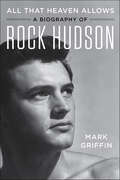
All That Heaven Allows: A Biography of Rock Hudson
by Mark Griffin“Paints a vivid portrait of a man who lived a double life in order to maintain his status as a movie star. . . . Candid but credible...a real page-turner.” —Leonard Maltin, author of Hooked on Hollywood: Discoveries from a Lifetime of Film FandomThe inspiration for the HBO® Original Documentary, Rock Hudson: All that Heaven Allowed.Rock Hudson was the ultimate movie star. The embodiment of romantic masculinity in American film throughout the ‘50s and ‘60s, he reigned supreme as the king of Hollywood.As an Oscar-nominated leading man, Hudson won acclaim for his performances in melodramas (Magnificent Obsession), western epics (Giant) and blockbuster bedroom farces (Pillow Talk). In the ‘70s and ‘80s, Hudson successfully transitioned to television with his long-running series McMillan & Wife and a recurring role on Dynasty.The Hollywood icon appeared to have it all. Yet beneath the star persona, there was a deeply conflicted human being. Growing up poor in Winnetka, Illinois, Hudson was abandoned by his father, abused by an alcoholic stepfather, and controlled by his domineering mother.Despite the obstacles, Hudson was determined to become an actor. After signing with agent Henry Willson, Hudson was transformed from a tongue-tied truck driver into Universal Studio’s resident Adonis. But Hudson’s wholesome screen image was at odds with his closeted homosexuality.Because of his secret gay relationships, Hudson was continually threatened with public exposure. In 1985 the public learned that the actor was battling AIDS, a disclosure that focused worldwide attention on the epidemic.Drawing on more than 100 interviews, All That Heaven Allows delivers a complete and nuanced portrait of one of the most fascinating stars in cinema history.“Provides trenchant cinematic insight and social criticism.” —Library Journal, starred review“Engrossing.” —Kirkus Reviews
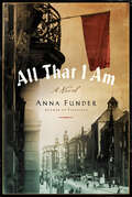
All That I Am: A Novel
by Anna FunderAn award-winner “writes with grace and conviction about the intrusion of the political on the domestic and the thrill of falling in love over a cause” (New York Times Book Review).When eighteen-year-old Ruth Becker visits her cousin Dora in Munich in 1923, she meets the love of her life, the dashing young journalist Hans Wesemann, and eagerly joins in the heady activities of the militant political Left in Germany. Ten years later, Ruth and Hans are married and living in Berlin when Hitler is elected chancellor. Together with Dora and her lover, Ernst Toller, the celebrated poet and self-doubting revolutionary, the four become hunted outlaws overnight and are forced to flee to London. Inspired by the fearless Dora to breathtaking acts of courage, the friends risk betrayal and deceit as they dedicate themselves to a dangerous mission: to inform the British government of the very real Nazi threat to which it remains willfully blind.Gripping and inspiring, All that I Am is a masterful novel of the risks and sacrifices some people make for their beliefs, and of heroism hidden in the most unexpected places.“An intimate exploration of human connection and our responsibility to one another” —Colum McCann, National Book Award winning author of Let the Great World Spin“Moving and ambitious.” —Ann Patchett, New York Times bestselling author of Tom Lake“Enthralling.” —O, the Oprah Magazine“A literary work as suspenseful as the best thrillers.” —Booklist“A remarkable story told with clarity and precision . . . insight and literary grace.” —Rachel Cusk, The Guardian“This book is a wonder.” —Jonathan Mirsky, The Spectator“Imaginative, compassionate and convincing.” —Wall Street Journal
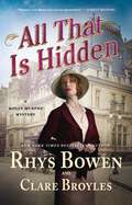
All That Is Hidden: A Molly Murphy Mystery (Molly Murphy Mysteries #19)
by Rhys Bowen Clare Broyles"Retired" detective and police captain's wife Molly Murphy Sullivan tangles with Tammany Hall in the next in Rhys Bowen and Clare Broyles's New York Times bestselling historical mystery series.New York, Autumn, 1907: Former private detective Molly Murphy Sullivan is happy with her place in the world. She and her policeman husband, Daniel, have built quite a life for themselves in Greenwich Village, in their modest-yet-beautiful-home in Patchin Place, filled with family, friends, and laughter. Molly and Daniel have a good marriage, a true partnership where they value each other’s opinions in all things.So when he tells her they’re moving to a fancy home on Fifth Avenue—and that he’s running for the sheriff of New York—Molly is left reeling. Daniel begs Molly to trust him, but why would he run for sheriff on the Tammany ticket? A party known more for kickbacks and quid pro quo than anything else, it used to be everything Daniel despised. So what’s changed? And why didn’t he discuss it with her beforehand? Molly can’t help but wonder what Daniel’s got himself tangled up in… and whether he needs her help to get out.In this next installment in this beloved series All That Is Hidden, the incomparable Molly is drawn into the dangerous world of politics, forced to navigate through the webs of lies and deceit which are hidden behind a veil of vast wealth and grandeur.
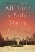
All That Is Solid Melts into Air: A Novel
by Darragh McKeon“Brilliantly imagined in its harrowing account of the Chernobyl disaster and exhilarating in its sweep, All That Is Solid Melts into Air is a debut to rattle all the windows and open up the ventricles of the heart. . . . The book is daring, exhilarating, generous and beautifully written.” — Colum McCannA brilliant and gripping novel set against the tragedy of Chernobyl and the way in which the lives of its survivors were forever changed in its wake. Part historical epic, part love story, it recalls The English Patient in its mix of emotional intimacy and sweeping landscape.Russia, 1986. On a run-down apartment block in Moscow, a nine-year-old prodigy plays his piano silently for fear of disturbing the neighbors. In a factory on the outskirts of the city, his aunt makes car parts, hiding her dissident past. In a nearby hospital, a surgeon immerses himself in his work, avoiding his failed marriage.And in a village in Belarus, a teenage boy wakes to a sky of the deepest crimson. Outside, the ears of his neighbor's cattle are dripping blood. Ten miles away, at the Chernobyl Power Plant, something unimaginable has happened. Now their lives will change forever.An end-of-empire novel charting the collapse of the Soviet Union, All That Is Solid Melts into Air is a riveting and epic love story by a major new talent.
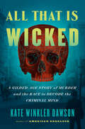
All That Is Wicked: A Gilded-Age Story of Murder and the Race to Decode the Criminal Mind
by Kate Winkler DawsonAcclaimed crime historian, podcaster, and author of American Sherlock Kate Winkler Dawson tells the thrilling story of Edward Rulloff—a serial murderer who was called &“too intelligent to be killed&”—and the array of 19th century investigators who were convinced his brain held the key to finally understanding the criminal mind.Edward Rulloff was a brilliant yet utterly amoral murderer—some have called him a &“Victorian-era Hannibal Lecter&”—whose crimes spanned decades and whose victims were chosen out of revenge, out of envy, and sometimes out of necessity. From his humble beginnings in upstate New York to the dazzling salons and social life he established in New York City, at every turn Rulloff used his intelligence and regal bearing to evade detection and avoid punishment. He could talk his way out of any crime...until one day, Rulloff's luck ran out. By 1871 Rulloff sat chained in his cell—a psychopath holding court while curious 19th-century "mindhunters" tried to understand what made him tick. From alienists (early psychiatrists who tried to analyze the source of his madness) to neurologists (who wanted to dissect his brain) to phrenologists (who analyzed the bumps on his head to determine his character), each one thought he held the key to understanding the essential question: is evil born or made? Eventually, Rulloff&’s brain would be placed in a jar at Cornell University as the prize specimen of their anatomy collection...where it still sits today, slowly moldering in a dusty jar. But his story—and its implications for the emerging field of criminal psychology—were just beginning. Expanded from season one of her hit podcast on the Exactly Right network (7 million downloads and growing), in All That Is Wicked Kate Winkler Dawson draws on hundreds of source materials and never-before-shared historical documents to present one of the first glimpses into the mind of a serial killer—a century before the term was coined—through the scientists whose work would come to influence criminal justice for decades to come.
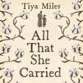
All That She Carried: The Journey of Ashley's Sack, a Black Family Keepsake
by Tiya MilesNATIONAL BOOK AWARD WINNER * NEW YORK TIMES BESTSELLER * WINNER OF THE CUNDILL HISTORY PRIZEIn 1850s South Carolina, an enslaved woman named Rose faced a crisis: the imminent sale of her daughter Ashley. Thinking quickly, she packed a cotton bag for her with a few items, and, soon after, the nine-year-old girl was separated from her mother and sold. Decades later, Ashley's granddaughter Ruth embroidered this family history on the sack in spare, haunting language.Historian Tiya Miles carefully traces these women's faint presence in archival records, and, where archives fall short, she turns to objects, art, and the environment to write a singular history of the experience of slavery, and the uncertain freedom afterward, in the United States. All That She Carried is a poignant story of resilience and lovepassed down against steep odds. It honours the creativity and resourcefulness of people who preserved family ties when official systems refused to do so, and it serves as a visionary illustration of how to reconstruct and recount their stories today.
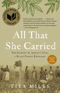
All That She Carried: The Journey of Ashley's Sack, a Black Family Keepsake
by Tiya MilesA renowned historian traces the life of a single object handed down through three generations of Black women to craft an extraordinary testament to people who are left out of the archives.&“A history told with brilliance and tenderness and fearlessness.&”—Jill Lepore, author of These Truths: A History of the United StatesIn 1850s South Carolina, an enslaved woman named Rose faced a crisis, the imminent sale of her daughter Ashley. Thinking quickly, she packed a cotton bag with a few precious items as a token of love and to try to ensure Ashley&’s survival. Soon after, the nine-year-old girl was separated from her mother and sold.Decades later, Ashley&’s granddaughter Ruth embroidered this family history on the bag in spare yet haunting language— including Rose&’s wish that &“It be filled with my Love always.&” Ruth&’s sewn words, the reason we remember Ashley&’s sack today, evoke a sweeping family story of loss and of love passed down through generations. Now, in this illuminating, deeply moving new book inspired by Rose&’s gift to Ashley, historian Tiya Miles carefully unearths these women&’s faint presence in archival records to follow the paths of their lives—and the lives of so many women like them—to write a singular and revelatory history of the experience of slavery, and the uncertain freedom afterward, in the United States.The search to uncover this history is part of the story itself. For where the historical record falls short of capturing Rose&’s, Ashley&’s, and Ruth&’s full lives, Miles turns to objects and to art as equally important sources, assembling a chorus of women&’s and families&’ stories and critiquing the scant archives that for decades have overlooked so many. The contents of Ashley&’s sack— a tattered dress, handfuls of pecans, a braid of hair, &“my Love always&”—are eloquent evidence of the lives these women lived. As she follows Ashley&’s journey, Miles metaphorically unpacks the bag, deepening its emotional resonance and exploring the meanings and significance of everything it contained.All That She Carried is a poignant story of resilience and of love passed down through generations of women against steep odds. It honors the creativity and fierce resourcefulness of people who preserved family ties even when official systems refused to do so, and it serves as a visionary illustration of how to reconstruct and recount their stories today.
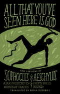
All That You've Seen Here Is God
by Sophocles Aeschylus Bryan DoerriesThese contemporary translations of four Greek tragedies speak across time and connect readers and audiences with universal themes of war, trauma, suffering, and betrayal. Under the direction of Bryan Doerries, they have been performed for tens of thousands of combat veterans, as well as prison and medical personnel around the world. Striking for their immediacy and emotional impact, Doerries brings to life these ancient plays, like no other translations have before.
All The Dark Secrets: The First Heartwarming, Heartrending Saga In The Beloved Families Of Fairley Terrace Series (The\families Of Fairley Terrace Ser. #1)
by Jennie FeltonAll The Dark Secrets is a powerful saga in the Families of Fairley Terrace series from Jennie Felton, in the grand tradition of Katie Flynn, Dilly Court and Josephine Cox, of one woman's quest for happiness after a bitter tragedy, filled with romance, drama and triumph in adversity.Shattered by tragedy, can the Donovan family find happiness again?When terrible tragedy strikes at the local colliery, the residents of Fairley Terrace's ten houses suffer more than one loss and, for Maggie Donovan at number six, the world turns upside down. Turning for comfort to the one man she can trust, she finds a sudden and undeniable passion instead. But any future with Josh Withers seems a betrayal of her past, and Maggie realises the only way to survive is to conceal a very dark secret of her own...*Includes a preview of the next book in the series and bonus material from the author.*Don't miss Jennie's Families of Fairley Terrace series, which began with Maggie's story in All The Dark Secrets and continued with Lucy's story in The Miner's Daughter, Edie's story in The Girl Below Stairs, Carina's story in The Widow's Promise and Laurel's story in The Sister's Secret.
All The Dark Secrets: The first heartwarming, heartrending saga in the beloved Families of Fairley Terrace series (The Families of Fairley Terrace #1)
by Jennie FeltonThe compelling first book in the beloved classic series from 'one of the nation's favourite saga author' (Lancashire Post) in the grand tradition of Katie Flynn, Dilly Court and Josephine Cox.Jennie's heartwarming and heartrending sagas are richly praised!'Jennie Felton knows how to tell a cracking story and keep the reader gripped... if you enjoy reading books in the style of Catherine Cookson then this one is for you' Books With Wine and Chocolate'Another superbly woven and character-rich story from a saga author who writes from the heart' Peterborough Telegraph'Packed full of Jennie's signature strong heroines, this book will keep you guessing' MNR JournalShattered by tragedy, can the Donovan family find happiness again?When terrible tragedy strikes at the local colliery, the residents of Fairley Terrace's ten houses suffer more than one loss and, for Maggie Donovan at number six, the world turns upside down. Turning for comfort to the one man she can trust, she finds a sudden and undeniable passion instead. But any future with Josh Withers seems a betrayal of her past, and Maggie realises the only way to survive is to conceal a very dark secret of her own...*Includes a preview of the next book in the series and bonus material from the author.*Don't miss Jennie's the rest Families of Fairley Terrace series, which begins with Maggie's story in All The Dark Secrets and continues with Lucy's story in The Miner's Daughter, Edie's story in The Girl Below Stairs, Carina's story in The Widow's Promise and Laurel's story in The Sister's Secret.Plus look out for Jennie's page-turning standalones - The Stolen Child, A Mother's Sacrifice and The Smuggler's Girl - coming soon!
All The Dark Secrets: The first heartwarming, heartrending saga in the beloved Families of Fairley Terrace series (The Families of Fairley Terrace #1)
by Jennie FeltonA powerful new saga in the grand tradition of Katie Flynn, Dilly Court and Josephine Cox, of one woman's quest for happiness after a bitter tragedy, filled with romance, drama and triumph in adversity.When terrible tragedy strikes at the local colliery, the residents of Fairley Terrace's ten houses suffer more than one loss and, for Maggie Donovan at number six, the world turns upside down. Turning for comfort to the one man she can trust, she finds a sudden and undeniable passion instead. But any future with Josh Withers seems a betrayal of her past, and Maggie realises the only way to survive is to conceal a very dark secret of her own...For more of the Families of Fairley Terrace, look for the next compelling saga in the series, The Miner's Daughter.(P)2014 Headline Digital
All The Devils Are Here: The Hidden History of the Financial Crisis
by Bethany Mclean Joe Nocera"Hell is empty, and all the devils are here." - Shakespeare, The Tempest. As soon as the financial crisis erupted, the finger-pointing began. Should the blame fall on Wall Street, Main Street, or Pennsylvania Avenue? On greedy traders, misguided regulators, sleazy subprime companies, cowardly legislators, or clueless home buyers? According to Bethany McLean and Joe Nocera, two of America's most acclaimed business journalists, the real answer is all of the above - and more. Many devils helped bring hell to the economy. And the full story, in all of its complexity and detail, is like the legend of the blind men and the elephant. Almost everyone has missed the big picture. Almost no one has put all the pieces together. All the Devils Are Here goes back several decades to weave the hidden history of the financial crisis in a way no previous book has done. It explores the motivations of everyone from famous CEOs, cabinet secretaries, and politicians to anonymous lenders, borrowers, analysts, and Wall Street traders. It delves into the powerful American mythology of homeownership. And it proves that the crisis ultimately wasn't about finance at all; it was about human nature. Among the devils you'll meet in vivid detail: Angelo Mozilo, the CEO of Countrywide, who dreamed of spreading homeownership to the masses, only to succumb to the peer pressure - and the outsized profits - of the sleaziest subprime lending. Roland Arnall, a respected philanthropist and diplomat, who made his fortune building Ameriquest, a subprime lending empire that relied on blatantly deceptive lending practices. Hank Greenberg, who built AIG into a Rube Goldberg contraption with an undeserved triple-A rating, and who ran it so tightly that he was the only one who knew where all the bodies were buried. Stan O'Neal of Merrill Lynch, aloof and suspicious, who suffered from "Goldman envy" and drove a proud old firm into the ground by promoting cronies and pushing out his smartest lieutenants. Lloyd Blankfein, who helped turn Goldman Sachs from a culture that famously put clients first to one that made clients secondary to its own bottom line. Franklin Raines of Fannie Mae, who (like his predecessors) bullied regulators into submission and let his firm drift away from its original, noble mission. Brian Clarkson of Moody's, who aggressively pushed to increase his rating agency's market share and stock price, at the cost of its integrity. Alan Greenspan, the legendary maestro of the Federal Reserve, who ignored the evidence of a growing housing bubble and turned a blind eye to the lending practices that ultimately brought down Wall Street - and inflicted enormous pain on the country. Just as McLean's The Smartest Guys in the Room was hailed as the best Enron book on a crowded shelf, so will All the Devils Are Here be remembered for finally making sense of the meltdown and its consequences. (Includes pages of photos and captions after the index.)
All The King's Men: The British Soldier from the Restoration to Waterloo
by Saul DavidSaul David's All The King's Men is a thrilling history of the British Redcoat from the English Civil War to Waterloo.Between 1660 and 1815 British supremacy on foreign soil was near total. Central to this success was the humble redcoat soldier who showed heroism in battle and stoicism in peace, despite appalling treatment. This is their story: of brutal discipline and inedible food, of loyalty and low pay, of barracks and battlefield - of victory, defeat, life and death.Praise for All The King's Men:'An extraordinary story, packed with drama, incident and great characters...All The King's Men is all you could hope for...Quite an achievement', Patrick Bishop, Country Life'A heady mixture of heroism, incompetence, devilish tactics and plain good luck', Sunday Times 'Filled with swashbuckling derring-do, the reek of blood and gunpowder, combined with shrewd analysis of power, war and psychology', Simon Sebag Montefiore Saul David is Professor of War Studies at the University of Buckingham and the author of several critically acclaimed books, including The Indian Mutiny: 1857, Zulu and, most recently, Victoria's Wars: The Rise of Empire. He recently presented 'Bullets, Boots and Bandages' for BBC 4 and is a regular contributor to Radio 4.