- Table View
- List View
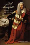
Lord Mansfield: Justice in the Age of Reason
by Norman PoserThe life and times of the great eighteenth-century judge and statesman, whose legacy continues to influence Anglo-American law and society.
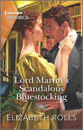
Lord Martin's Scandalous Bluestocking
by Elizabeth RollsA formerly engaged couple torn apart by scandal are reunited when the lady goes to the ex-fiancé she still loves for help in this Regency romance.Since Kit Selbourne scandalously broke her betrothal to Lord Martin Lacy, she’s become an independent woman, running her uncle’s bookshop. But when her uncle is murdered, Kit must turn to Martin for help—and she discovers the desire between them still burns strongly. Yet Kit is wedded to her new, free life . . . unless Martin can finally convince his courageous bluestocking that their marriage would be one of equals . . .
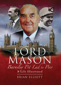
Lord Mason, Barnsley Pitlad to Peer: A Life Illustrated
by Brian ElliottRoy Mason swapped the colliery for Westminster when elected MP for Barnsley in 1953. He went on to become one of the leading figures in the Labour Party during the 1960s and 1970s, holding a number of prestigious offices including Defence Secretary from 1974 and Secretary of State for Northern Ireland from 1976. This photographic biography presents images from Mason's own archive charting his personal and political life from the Yorkshire pits to the House of Lords.
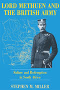
Lord Methuen and the British Army: Failure and Redemption in South Africa
by Stephen M. MillerThis study analyzes the readiness of the British military establishment for war in 1899 and its performance in the South African War (1899-1902). It focuses on the career of Field Marshal Paul Sanford, 3rd Baron Methuen, whose traditional military training, used so effectively in Queen Victoria's small wars, was put to the test by the modern challenges of the South African War. A subsidiary aim of this work is to correct and refine the historical consensus that Methuen's campaing in the South African War was plagued by practical errors and poor judgement. The South African War was a crucial transitional episode in the history of the British army. Unlike Great Britain's other expeditions, it required the concentrated resources of the entire empire. It was a modern war in the sense that it employed the technology, the weaponry, the communications, and the transportation of the second industrial revolution.
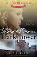
Lord Monroe's Dark Tower
by Elf AhearnTwo years of bewildering silence have passed since Claire Albright's passions were first inflamed by the powerful, brooding Lord Flavian Monroe. On the brink of her debut in London he suddenly summons her, asking that she use her knowledge of healing to help his ward - a girl who hoards castoffs in memory of her dead brother. Embroiled in a desperate attempt to curb the child's destructive madness, Claire struggles to understand Flavian's burning kisses yet cold demeanor. Can she reach his heart before his ward's insanity undoes Claire's chance at love?When he was fourteen, Flavian made a mistake so devastating it ruined all hope for happiness. Years later, he's still paying for his sin. But before his ward's troubled mind destroys his home and family, he must see Claire once more. Vowing to keep their relationship professional - she the healer, he the guardian - he finds the bonds of his resolve snapping. Somehow, he must content himself with the love that could have been . . . but he cannot resist one final embrace . . .Sensuality Level: Sensual
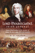
Lord Mountcashel: Justin MacCarthy in the Service of James II and Louis XIV, 1673–1694
by D. P. GrahamJustin MacCarthy (later Lord Mountcashel) was born into a notable family of Irish Jacobites, loyal to the exiled Stuarts, and grew up in France. Their Irish land was regained after the Restoration of Charles II but Justin, as the youngest surviving son, sought a career in the French army (as both his father and oldest brother had done). In 1673 he joined an Irish regiment in French service. He served under the legendary French marshals Turenne and Conde against the Dutch and their Imperial allies and by 1676 was commanding the regiment. He became part of the personal circle of the Catholic Duke of York, the future James II and, after the latters accession in 1685, Justin helped to transform the Irish army into a Catholic one.When James II was deposed in the Glorious Revolution of 1688 and fled via France to Ireland, Justin was one of the most experienced commanders resisting Williams invasion. Unfortunately MacCarthy was defeated at the Battle of Newtownbutler (1689), wounded and captured. He escaped and again went into exile in France, where he was the first commander of the famous Irish Brigade until his death in 1694.
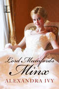
Lord Mumford's Minx
by Alexandra IvyDear Reader, Long before I wrote my sexy paranormal romances, I wrote traditional Regency romances as Debbie Raleigh. Now I’m delighted that one of my favorites is available once more, as full of romance—and surprises—as ever . . . When a woman appears at Stanholte Manor claiming to be the real heir to the family fortune, Miss Cassandra Stanholte determines to prove her a fraud. Cassie’s one clue leads her to the most notorious neighborhood in London—where she disguises herself as a courtesan. But her plan is hampered by the utterly exasperating, and irresistibly charming, Lord Luke Mumford. The man is apparently intrigued by her, and has a habit of turning up at the most inopportune times. Cassie prays he’ll tire of his obsession before he discovers the truth—and she falls any deeper in love….But Luke is a bored lord, looking for adventure. He’s determined to discover what the young miss is hiding. Yet what begins as a game becomes far more serious when the dashing gentleman finds he is losing his heart . . . I’m smitten with this tale of love and adventure all over again , and believe you will be too. Alexandra Ivy
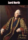
Lord North
by W. Baring PembertonOriginally published in 1938, this is a book on the life of Frederick North, 2nd Earl of Guilford (1732-1792), otherwise known by his courtesy title, Lord North.Lord North was Prime Minister of Great Britain from 1770-1782 and led Great Britain through most of the American War of Independence. He also held a number of other cabinet posts, including Home Secretary and Chancellor of the Exchequer.North’s reputation among historians has swung back and forth. In the late nineteenth century he was depicted as a creature of the king and an incompetent who lost the American colonies, but in the early twentieth century a revisionism emphasized his strengths in administering the Treasury, handling the House of Commons, and in defending the Church of England.With this book, author W. Baring Pemberton affirms his support for Lord North’s later reputation, aiming—as he himself professes—to show that “while North was not a great statesman, he is deserving of revaluation.”A fascinating look at the formerly ill-reputed “Prime Minister who lost America.”
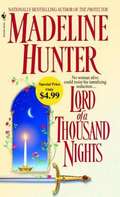
Lord Of A Thousand Nights (Medievals #5)
by Madeline HunterNo woman alive could resist his tantalizing seduction. . . . Celebrated as “one of the brightest new writers in the genre”(Publishers Weekly),Madeline Hunter has won the hearts of readers with the poignant passion of her love stories and the brilliance of her writing. Now this nationally bestselling, award-winning author delivers her freshest, most tantalizing romance yet. . . Called the Lord of a Thousand Nights, Ian of Guilford was famed as much for his feats in the bedroom as on the battlefield. But Lady Reyna Graham had no idea of this when, disguised as a courtesan, she passed behind enemy lines with a desperate plan to save her people. Now, sitting in the tent of the dizzyingly handsome warrior who commanded the army outside her gates, the beautiful widow suddenly realized that she had underestimated her foe. For she found herself in the company of a man whose charms were said to be impossible to resist. . . and who would show no mercy in laying siege to her heart—and body—with every sensual weapon in his arsenal. For the sake of her people, she must not give in . . . and she must somehow turn this legendary lover who never lost his heart into a man who would exchange all his thousand nights for one with her. . . .
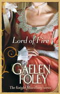
Lord Of Fire: Number 2 in series (Knight Miscellany #2)
by Gaelen FoleyAfter years of preparation, he has baited his trap well, luring the depraved members of Society into his devil's playground so he can earn their trust and uncover their secrets. Yet no one in London suspects that Lord Lucien Knight is England's most cunning spy, an officer who has sacrificed his soul for his country. Now an unexpected intruder has invaded his fortress of sin, jeopardizing his carefully laid plans - and igniting his deepest desires. Beautiful, innocent Alice Montague finds herself at the mercy of scandalous Lord Lucien. But as he begins his slow seduction to corrupt her virtue, Alice glimpses a man tormented by his own choices, a man who promises her nothing but his undeniable passion. . .
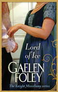
Lord Of Ice: Number 3 in series (Knight Miscellany #3)
by Gaelen FoleyDamien Knight, the earl of Winterley, is proud, aloof, and tormented by memories of war. Though living in seclusion, he is named guardian to a fellow officer's ward. Instead of the young homeless waif he was expecting, however, Miranda FitzHubert is a stunning, passionate beauty who invades his sanctuary and forces him back into society. Struggling to maintain honour and self-control, Damien now faces an ever greater threat: desire. A bold, free spirit, Miranda has witnessed the darkest depths of Damien's soul - and has seen his desperate need for love. But before she can thaw his unyielding heart, she must endure a terrifying nightmare of her own . . .
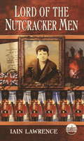
Lord Of The Nutcracker Men
by Iain LawrenceTen-year-old Johnny eagerly plays at war with the army of nutcracker soldiers his toymaker father whittles for him. He demolishes imaginary foes. But in 1914 Germany looms as the real enemy of Europe, and all too soon Johnny’s father is swept up in the war to end all wars. He proudly enlists with his British countrymen to fight at the front in France. The war, though, is nothing like what any soldier or person at home expected. The letters that arrive from Johnny’s dad reveal the ugly realities of combat — and the soldiers he carves and encloses begin to bear its scars. Still, Johnny adds these soldiers to his armies of Huns, Tommies, and Frenchmen, engaging them in furious fights. But when these games seem to foretell his dad’s real battles, Johnny thinks he possesses godlike powers over his wooden men. He fears he controls his father’s fate, the lives of all the soldiers in no-man’s land, and the outcome of the war itself. From the Hardcover edition.
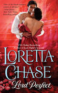
Lord Perfect (Carsington Family #3)
by Loretta ChaseTall, dark, and handsome, the heir to the Earl of Hargate, Benedict Carsington, is known for his impeccable manners and good breeding. Benedict knows all the rules and has no trouble following them--until Bathsheba Wingate enters his life. Now, the two must embark on a rescue mission that puts them in dangerous, intimate proximity. Fortunately, Benedict is in perfect control--despite his mad desire to break all the rules. Perfect control. Really.
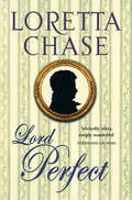
Lord Perfect: Number 3 in series (Carsington Quartet #3)
by Loretta ChaseTall, dark, and handsome, the heir to the Earl of Hargate, Benedict Carsington, is known for his impeccable manners and good breeding. Benedict knows all the rules and has no trouble following them - until Bathsheba Wingate enters his life. Bathsheba Wingate belongs to the rotten branch of the DeLucey family: a notorious bunch of liars, frauds and swindlers. Small wonder her husband's high-born family disowned him. Now widowed, Bathsheba is determined to give her young daughter a proper upbringing. Nothing and no one will disrupt her plans. Then Bathseba's hoyden daughter lures Benedict's precocious nephew into a quest for a legendary treasure. To recover the would-be knights errant, Benedict and Bathsheba must embark on a rescue mission that puts them in dangerous, intimate proximity. Fortunately, Benedict is in perfect control - despite his mad desire to break all the rules. Perfect control. Really.
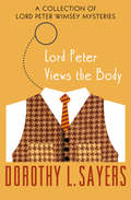
Lord Peter Views the Body: A Collection of Mysteries (The Lord Peter Wimsey Mysteries #4)
by Dorothy L. SayersA dozen whodunits to challenge the ingenious British aristocrat and sleuth—from &“one of the greatest mystery story writers&” (Los Angeles Times). Some aristocrats spend their lives shooting, but Lord Peter Wimsey is a hunter of a different kind: a bloodhound with a nose for murder. Before he became Britain&’s most famous detective, Lord Peter contented himself with solving the crimes he came across by chance. In this volume of short stories, he confronts a stolen stomach, a man with copper fingers, and a deadly adventure at Ali Baba&’s cave, among other conundrums. These mysteries tax not just his intellect, but his humor, knowledge of metallurgy, and taste for fine wines. It&’s not easy being a gentleman sleuth, but Lord Peter is the man for the job. Lord Peter Views the Body is the 4th book in the Lord Peter Wimsey Mysteries, but you may enjoy the series by reading the books in any order. This ebook features an illustrated biography of Dorothy L. Sayers including rare images from the Marion E. Wade Center at Wheaton College.
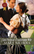
Lord Portman's Troublesome Wife
by Mary NicholsHomeless and penniless, Rosamund is forced to marry Lord Harry Portman. In return for a comfortable life, she must produce an heir! Harry's attraction to Rosamund is unsettling. It threatens the terms of their convenient marriage-and his undercover work bringing criminals to justice! Guilt over his first wife's death tortures Harry. But when Rosamund falls into danger, he has to find the courage to let go of the past and fight for the woman he loves. . . ;.
Lord Quillifer (Quillifer)
by Walter Jon Williams&“For all of you who need some great fantasy to read while you're waiting for The Winds of Winter...try Quillifer, by Walter Jon Williams. WJW is always fun, but this might be his best yet, a delight from start to finish, witty, colorful, exciting and amusing by turns, exquisitely written.&” —George R. R. Martin, author of the Song of Ice and Fire series &“Chock full of derring-do, blood and thunder, swashbuckling, and other good stuff.&” —Paul di Filippo, Locus&“You have risen as far as you can, and from this point, you may only fall. The matter is inevitable, and I need not intervene.&” Quillifer&’s archenemy, the beautiful and vengeful goddess Orlanda, predicts his inescapable fall from power, and Quillifer has to admit that she may be right. Quillifer has risen high at court. The butcher&’s son is now a lord, and now is the confidential agent of the state, the caretaker of the kingdom&’s secrets, and the secret lover of the young and brilliant Queen Floria. He finds himself surrounded by perils. The nobles are at odds with one another, but united in despising Quillifer. Someone has brought deadly poison into court, and Quillifer fears the Queen may be the intended victim. Another assassination plot is aimed at Quillifer himself, and an enemy nation has landed troops intending to topple Floria by force. Quillifer must solve every mystery, meet every danger, and discover every secret in order to guard himself and his love, Floria, from the dangers that beset them. Lord Quillifer marks the anticipated return of Walter Jon Williams, a New York Times bestselling author and multiple award-winning fantasy author.
Lord Radcliffe’s Season
by Jo Ann FergusonLady Lisabeth Montague is grateful to set aside mourning for her late husband. The match had been a mistake from the beginning, for she had been young and naïve enough to believe the court-promises of Frederick Montague, a rakehell viscount. Now her abusive, unfaithful husband is dead, and she is anxious to begin her life anew. She is shocked when a request comes from Frederick's cousin, Norton Radcliffe. Norton wishes her to tutor his own cousin Tristan Radcliffe, a marquess, in the ways of the ton. But Lord Radcliffe is no young boy. He is a veteran, who was wounded during the war and clearly has a mind of his own. Radcliffe, as he asks Lisabeth to call him, shares her uncertainty. It is a most peculiar feeling, one he has seldom known before. Kind but strict, Lisabeth helps him not only with the ways of the Polite World, but to walk again. That astounds him, because he was told she was a flirt who made her husband miserable. But the truth is in front of his eyes. Which is the real Lisabeth? He needs to know the truth as he falls in love, even though he knows she doesn't want to marry again. Maybe he needs to turn the tables and become her instructor . . . in how sweet kisses can be.
Lord Rakehell
by Virginia HenleySome men thrive on scandal. Lord James Hamilton, heir to the Duke of Abercorn and newly appointed attendant to the young Prince of Wales, is in no rush to find a wife and take on a more responsible life. A lover of all things pleasurable, James has earned his reputation as a rakehell of London. But when a feisty beauty piques his interest, James finds himself obsessed with learning more about her, and even contemplates making her his own. Lady Anne Curzon-Howe has long been besotted with her dear friends’ handsome elder brother, James-ever since the moment he compared her to a wild Irish rose. While Anne has many suitors, the elusive James is the only man who draws her fancy. But Lord Hamilton’s rakish ways are notorious for a reason, and convincing him to love only her will be an incredible-albeit rewarding-challenge. . . . MORE THAN 8 MILLION COPIES OF VIRGINIA HENLEY’S NOVELS IN PRINT .
Lord Randolph Churchill Volume 1 (Lord Randolph Churchill #1)
by Winston S. ChurchillThe first volume of the Nobel Prize-winning Prime Minister&’s biography of his father, the fiery Conservative Party leader of late Victorian Britain. In 1906, Sir Winston Churchill produced a two-volume biography of his father Lord Randolph Churchill, the 19th century Member of Parliament whose political career ended in scandal. This first volume deals with early events in Randolph&’s life, including his upbringing, his education, and his election to the House of Commons as the Conservative MP for Woodstock. This volume also recount&’s Randolph&’s quarrel with the Prince of Wales in a daring gambit to protect the integrity of the Churchill family name. This episode resulted in Churchill&’s temporary exile from British high society, a prequel to his later disgrace. While Winston Churchill is clearly a supporter of his father&’s, he is not afraid to be honest about the mistakes and failures of his career and personal life.
Lord Randolph Churchill Volume 2 (Lord Randolph Churchill #2)
by Winston S. ChurchillThe second volume of the Nobel Prize-winning Prime Minister&’s biography of his father, the controversial Victorian era British MP. In 1906, Sir Winston Churchill produced a two-volume biography of his father Lord Randolph Churchill, the 19th century Member of Parliament whose political career ended in scandal. This second volume detail&’s the elder Churchill&’s emergence as an independent leader who challenged the old guard of his own Conservative Party. As an obscure and overlooked backbench MP, Randolph established a cohort of Tory rebels known as the &“fourth party.&” Though excluded from British high society, he nevertheless made a name for himself and rose to become Chancellor of the Exchequer. But as he was on course to run for Prime Minister, his confrontational style led to a career-ending blunder.
Lord Ravenscar's Inconvenient Betrothal (Wild Lords and Innocent Ladies #2)
by Lara TempleA marquess and a stubborn heiress are trapped together—and the only solution is marriage . . . “Will thrill Regency fans.” —RT Book ReviewsAlan Rothwell, Marquess of Ravenscar, is furious when unconventional heiress Lily Wallace refuses him purchase of her property. He can’t even win her over with his infamous charm.But then he is seized by fever and they’re trapped together. Horrified, Alan realizes Lily’s attentions will compromise them both! His solution: take Lily as his betrothed before desire consumes them completely . . .“Ms. Temple has a real gift at creating deeply emotional and passionate characters.” —Chicks Rogues and Scandal“Temple has a delightful gift with words.” —RT Book Reviews
Lord Ravensden's Marriage
by Anne HerriesA young woman disappears. A husband is suspected of murder. Stirring times for all the neighborhood.When the debauched Marquis of Sywell won Steepwood Abbey years ago at cards, it led to the death of the then Earl of Yardley. Now he's caused scandal again by marrying a girl out of his class- and young enough to be his granddaughter! After being married only a short time, the marchioness has disappeared, leaving no trace of her whereabouts. There is every expectation that yet more scandals will emerge, though no one yet knows just how shocking they will be.Regency DramaIntrigue, mischief...and marriageThe Steepwood Scandal
Lord Robert Cecil: Politician and Internationalist
by Gaynor JohnsonLawyer, politician, diplomat and leading architect of the League of Nations; Robert Cecil, 1st Viscount Cecil of Chelwood, was one of Britain's most significant statesmen of the twentieth century. His views on international diplomacy cover the most important aspects of British, European and American foreign policy concerns of the century, including the origins and consequences of the two world wars, the disarmament movement, the origins and early course of the Cold War and the first steps towards European integration. His experience of the First World War and the huge loss of life it entailed provoked Cecil to spend his life championing the ethos behind and work of the League of Nations: a role for which he was awarded the Nobel Peace Prize in 1937. Yet despite his prominence in the international peace movement, Cecil has never been the focus of an academic biography. Cecil has perhaps been judged unfairly due to his association with the League of Nations, which has since been generally regarded as a failure. However, recent academic research has highlighted the contribution of the League to the creation of many of the institutions and precepts that have, since the Second World War, become accepted parts of the international system, not least the United Nations. In particular, Cecil and his work on arms control lay the basis for understanding this new area of international activity, which would bear fruit during the Cold War and after. Through an evaluation of Cecil's political career, the book also assesses his reputation as an idealist and the extent to which he had a coherent philosophy of international relations. This book suggests that in reality Cecil was a Realpolitiker pragmatist whose attitudes evolved during two key periods: the interwar period and the Cold War. It also proposes that where a coherent philosophy was in evidence, it owed as much to the moral and political code of the Cecil family as to his own experiences in politics. Cecil's social and familial world is therefore considered alongside his more public life.
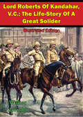
Lord Roberts Of Kandahar, V.C.: The Life-Story Of A Great Solider [Illustrated Edition]
by Walter JerroldIncludes 9 illustrations"As a leader of men in the field he is, I believe, without equal." -- Sir Alfred Milner on Lord RobertsIn this excellent short biography of Lord Roberts, Walter Jerrold, tells the tale of his many exploits and victories across the British Empire."Roberts won the Victoria Cross at Khudagani during the Indian Mutiny (1857-59) for repeated acts of gallantry, but first came to public notice during the Second Afghan War (1878-80) when he commanded the Kurram Field Force, leading it to victory at Peiwar Kotal in December 1878, and later the Kabul Field Force which occupied the Afghan capital in October 1879 following the murder of the British envoy."Roberts also led his troops on the legendary march from Kabul to Kandahar. Despite the difficult terrain and the high temperatures he covered 280 miles (400km) in 20 days and hardly lost a man. In September 1880 he defeated Ayub Khan outside Kandahar and relieved the besieged garrison. "After the early reverses of the Boer War (1899-1902), Roberts took over command of the British forces in South Africa. From December 1899, together with his Chief of Staff Major-General Horatio Herbert, Lord Kitchener, he revitalised the British military effort. Kindly, unassuming and courteous, Roberts was popularly known as 'Bobs'. His small stature and elderly appearance - he was 68 when he left South Africa in 1900 - probably increased the veneration which he received from both the public and soldiers."On returning to Britain he was made a Knight of the Garter and created Earl Roberts. Despite a bitter rivalry with the Wolseley ring, Roberts was made the last Commander-in-Chief of the British Army, a position he held for three years until 1904.After lying in state in Westminster Hall, one of only two non-Royals to do so in the 20th century, the other being Winston Churchill, he was given a state funeral."--NAM