- Table View
- List View
Remote Sensing for Geoscientists: Image Analysis and Integration, Third Edition
by Gary L. ProstThis third edition of the bestselling Remote Sensing for Geologists: A Guide to Image Interpretation is now titled Remote Sensing for Geoscientists: Image Analysis and Integration. The title change reflects that this edition applies to a broad spectrum of geosciences, not just geology; stresses that remote sensing has become more than photointerpre
Remote Sensing for Hydrocarbon Exploration (Springer Remote Sensing/Photogrammetry)
by Andreas LaakeThis book provides insights into the benefits of using remote sensing data from a geoscientist's perspective, by integrating the data with the understanding of Earth's surface and subsurface. In 3 sections, the book takes a detailed look at what data explorationists use when they explore for hydrocarbon resources, assess different terrain types for planning and hazards and extract present-day geologic analogs for subsurface geologic settings. The book presents the usage of remote sensing data in exploration in a structured way by detecting individual geologic features as building blocks for complex geologic systems. This concept enables readers to build their own workflows for the assessment of complex geologic systems using various combinations of remote sensing data. Section 1 introduces readers to the foundations of remote sensing for exploration, covers various methods of image processing and studies different digital elevation and bathymetry models. Section 2 presents the concept of geomorphology as a means to integrate surface and subsurface data. Different aspects of rendering in 2D and 3D are explained and used for the interpretation and extraction of geologic features that are used in exploration.Section 3 addresses remote sensing for hydrocarbon exploration in detail, from geophysical data acquisition to development and infrastructure planning. The organization of this chapter follows an exploration workflow from regional to local modeling studying basin and petroleum system modeling as well as logistics planning of seismic surveys and near-surface modeling. Aspects of field development and infrastructure planning comprise multi-temporal and dynamic modeling. The section closes with a structured approach to extracting geologic analogs from interpreted remote sensing data.The book will be of interest to professionals and students working in exploration for hydrocarbons and water resources, as well as geoscientists and engineers using remote sensing for infrastructure planning, hazard assessment and dynamic environmental studies.
Remote Sensing for Landscape Ecology: Monitoring, Modeling, And Assessment Of Ecosystems
by Ricardo D Lopez Robert C FrohnThis book provides the practical basis for the use of remote sensing to accomplish landscape ecological projects, through the merging of theory and practice, with examples. This is a specialized application and both these topics have evolved rapidly in the past decade. This evolution is not in the previous edition, and indeed this update provides much new information and valuable ideas for the professional and assist in directing the training of new personnel. The new edition will feature a combination of landscape ecology metrics, quantitative field measurements, and geospatial analyses.
Remote Sensing for Malaria: Monitoring and Predicting Malaria from Operational Satellites (Springer Remote Sensing/Photogrammetry)
by Felix KoganThis book presents research using high-resolution operational satellite data for monitoring and assessing numerically how to reduce the area and intensity of malaria outbreaks. Satellite data and imageries a powerful and effective tool for malaria monitoring and reduction of the number of affected people as it bypasses the limitations imposed by the dearth of near-the-ground weather data in many malaria-prone areas. With this in mind, this volume provides readers with:In-depth information in monitoring signs of malaria from operational polar-orbiting satellitesExamples of country-specific models for predicting malaria area (1 and 4 km2 resolution) and intensityInformation on the how the effects of climate change on malaria outbreak area and intensity can be monitoredA new Vegetation Health (VH) methodology to estimate vegetation moisture, temperature and moisture/temperature conditions as indicators of malaria vector activityAdvice to users on the application of VH technology for early assessments of malaria area, intensity and risk levelRemote Sensing for Malaria is intended for an audience of public health practitioners, environmentalists, and students and researchers working in spatial epidemiology and disease prevention.
Remote Sensing for Sustainability (Remote Sensing Applications Series)
by Qihao WengDriven by the societal needs and improvement in sensor technology and image processing techniques, remote sensing has become an essential geospatial tool for understanding the Earth and managing Human-Earth interactions. Remote Sensing for Sustainability introduces the current state of the art remote sensing knowledge integral for monitoring the world’s natural resources and environments, managing exposure to natural disasters and man-made risks, and helping understand the sustainability and productivity of natural ecosystems. Bridging the gap between remote sensing and sustainability science this book examines theories and methods as well as practical applications of sustainable development for cities using remote sensing; focuses on remote sensing methods and techniques for sustainable natural resources with emphasize on forests; answers questions on how and what the remote sensing methods and techniques can do for the sustainability of environmental systems; and examines the issues of energy use and sustainable energy sources using remote sensing technology in countries such as Germany, China, the U.S, drawing on case studies to demonstrate the applicability of remote sensing techniques. This comprehensive guide, which can serve to professors, researchers, and students alike, takes in consideration the United Nations set of sustainable development goals and intends to contribute to the GEO’s Strategic Plan by addressing and exemplifying a number of societal benefit areas of remote sensing data sets, methods, and techniques for sustainable development.
Remote Sensing for Sustainable Forest Management
by Steven E. FranklinAs remote sensing data and methods have become increasingly complex and varied - and increasingly reliable - so have their uses in forest management. New algorithms have been developed in virtually every aspect of image analysis, from classification to enhancements to estimating parameters. Remote Sensing for Sustainable Forest Management reviews t
Remote Sensing from Space
by Gunter Zeug Martino Pesaresi Stefan Schneiderbauer Bhupendra JasaniThis volume provides the reader with an overview of the state-of-the-art Earth Observation (EO) related research that deals with national and international security. An interdisciplinary approach was adopted in this book in order to provide the reader with a broad understanding on the uses of remote sensing technologies. The book therefore comprises management aspects (issues and priorities of security research, crisis response), applied methodologies and process chains (treaty monitoring, estimation of population densities and characteristics, border permeability models, damage assessment) and the latest developments in generic tools (feature recognition, change detection and visualization). Moreover, issues of data sharing and standards, as well as new approaches to training security relevant techniques, are addressed. The contributing authors are leading researchers and experts from private companies, national research institutions and international organizations, all of whom were brought together under the aegis of the European research project GMOSS (Global Monitoring for Security and Stability). This book is tailored for the scientific community that deals with the application of EO data, as well as project managers and decision makers working in the field of security having an interest in technical solutions. The integrative use of many figures and sample images are ideal in enabling the non-technical reader to grasp quickly the modern technologies that are being researched in the area of civil security.
Remote Sensing in ArcGIS® Pro
by Tammy E. Parece James B. Campbell John A. McGeeRemotely sensed images are widely available and have countless potential applications. In the past, analyzing these images required specialized software. Esri’s ArcGIS Pro software includes tools that can be used by novice and experienced analysts. In this manual, we provide a series of easy-to-understand, step-by-step tutorials to guide you through image analysis processes. By completing this series of tutorials, you will be able to: •Manipulate data in ArcGIS Pro •Obtain and display Landsat data •Display image data from Landsat or other remote sensing platforms (including Sentinel and sUAS) •Enhance and analyze remotely sensed imagery.Videos available through the Virginia Geospatial Extension Program’s YouTube Channel can be used as additional resources to accompany this manual.
Remote Sensing of Agriculture and Land Cover/Land Use Changes in South and Southeast Asian Countries
by Krishna Prasad Vadrevu Chris Justice Thuy Le Toan Shibendu Shankar RayThis book sheds new light on the remote sensing of agriculture in South/Southeast Asian (S/SEA) countries. S/SEA countries are growing rapidly in terms of population, industrialization, and urbanization. One of the critical challenges in the region is food security. In S/SEA, although total food production and productivity have increased in previous decades, in recent years, the growth rate of food production has slowed down, mostly due to land use change, market forces and policy interventions. Further, the weather and climate systems in the region driven primarily by monsoon variability are resulting in droughts or flooding, impacting agricultural production. Therefore, monitoring crops, including agricultural land cover changes at regular intervals, is essential to predict and prepare for disruptions in the food supply in the S/SEA countries. The current book captures the latest research on the remote sensing of agricultural land cover/ land use changes, including mapping and monitoring crops, crop yields, biophysical parameter retrievals, multi-source data fusion for agricultural applications, and chapters on decision making and early warning systems for food security. The authors of this book are international experts in the field, and their contributions highlight the use of remote sensing and geospatial technologies for agricultural research and applications in South/Southeast Asia.
Remote Sensing of Clouds and Precipitation (Springer Remote Sensing/photogrammetry Ser.)
by Constantin AndronacheThis book presents current applications of remote sensing techniques for clouds and precipitation for the benefit of students, educators, and scientists. It covers ground-based systems such as weather radars and spaceborne instruments on satellites. Measurements and modeling of precipitation are at the core of weather forecasting, and long-term observations of the cloud system are vital to improving atmospheric models and climate projections. The first section of the book focuses on the use of ground-based weather radars to observe and measure precipitation and to detect and forecast storms, thunderstorms, and tornadoes. It also discusses the observation of clouds using ground-based millimeter radar. The second part of the book concentrates on spaceborne remote sensing of clouds and precipitation. It includes cases from the Tropical Rainfall Measuring Mission (TRMM) and the Global Precipitation Measurement (GPM) mission, using satellite radars to observe precipitation systems. Then, the focus is on global cloud observations from the ClaudSat, Cloud-Aerosol Lidar and Infrared Pathfinder Satellite Observation (CALIPSO), including a perspective on the Earth Clouds, Aerosols, and Radiation Explorer (EarthCARE) satellite. It also addresses global atmospheric water vapor profiling for clear and cloudy conditions using microwave observations. The final part of this volume provides a perspective into advances in cloud modeling using remote sensing observations.
Remote Sensing of Coastal Environments (Remote Sensing Applications Series)
by Yeqiao WangAs coastal environments around the world face unprecedented natural and anthropogenic threats, advancements in the technologies that support geospatial data acquisition, imaging, and computing have profoundly enhanced monitoring capabilities in coastal studies. Providing systematic treatment of the key developments, Remote Sensing of Coastal Enviro
Remote Sensing of Drought: Innovative Monitoring Approaches (Drought and Water Crises)
by Brian D. Wardlow Martha C. Anderson James P. VerdinRemote Sensing of Drought: Innovative Monitoring Approaches presents emerging remote sensing-based tools and techniques that can be applied to operational drought monitoring and early warning around the world. The first book to focus on remote sensing and drought monitoring, it brings together a wealth of information that has been scattered through
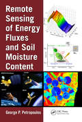
Remote Sensing of Energy Fluxes and Soil Moisture Content
by George P. PetropoulosIntegrating decades of research conducted by leading scientists in the field, Remote Sensing of Energy Fluxes and Soil Moisture Content provides an overview of state-of-the-art methods and modeling techniques employed for deriving spatio-temporal estimates of energy fluxes and soil surface moisture from remote sensing. It also underscores the range
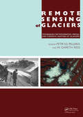
Remote Sensing of Glaciers: Techniques for Topographic, Spatial and Thematic Mapping of Glaciers
by Petri Pellikka W. Gareth ReesGlaciers and ice sheets have been melting significantly during recent decades, posing environmental threats at local, regional and global scales. Changes in glaciers are one of the clearest indicators of alterations in regional climate, since they are governed by changes in accumulation (from snowfall) and ablation (by melting of ice). Glacier chan

Remote Sensing of Global Croplands for Food Security (Remote Sensing Applications Series)
by Prasaii S. Thenkabail John G. Lvon Hulgh Tiirral Chanirashelhar M. BiraiaakIncreases in populations have created an increasing demand for food crops while increases in demand for biofuels have created an increase in demand for fuel crops. What has not increased is the amount of croplands and their productivity. These and many other factors such as decreasing water resources in a changing climate have created a crisis like
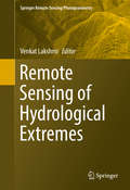
Remote Sensing of Hydrological Extremes
by Venkat LakshmiThis volume provides in-depth coverage of the latest in remote sensing of hydrological extremes: both floods and droughts. The book is divided into two distinct sections - floods and droughts - and offers a variety of techniques for monitoring each. With rapid advances in computer modelling and observing systems, floods and droughts are studied with greater precision today than ever before. Land surface models, especially over the entire Continental United States, can map the hydrological cycle at kilometre and sub-kilometre scales. In the case of smaller areas there is even higher spatial resolution and the only limiting factor is the resolution of input data. In-situ sensors are automated and the data is directly relayed to the world wide web for many hydrological variables such as precipitation, soil moisture, surface temperature and heat fluxes. In addition, satellite remote sensing has advanced to providing twice a day repeat observations at kilometre to ten-kilometre spatial scales. We are at a critical juncture in the study of hydrological extremes, and the GPM and SMAP missions as well as the MODIS and GRACE sensors give us more tools and data than were ever available before. A global variety of chapter authors provides wide-ranging perspectives and case studies that will make this book an indispensable resource for researchers, engineers, and even emergency management and insurance professionals who study and/or manage hydrological extremes.
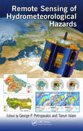
Remote Sensing of Hydrometeorological Hazards
by Tanvir Islam George P. PetropoulosExtreme weather and climate change aggravate the frequency and magnitude of disasters. Facing atypical and more severe events, existing early warning and response systems become inadequate both in scale and scope. Earth Observation (EO) provides today information at global, regional and even basin scales related to agrometeorological hazards. This book focuses on drought, flood, frost, landslides, and storms/cyclones and covers different applications of EO data used from prediction to mapping damages as well as recovery for each category. It explains the added value of EO technology in comparison with conventional techniques applied today through many case studies.
Remote Sensing of Impervious Surfaces (Remote Sensing Applications Series)
by Qihao WengRemote sensing of impervious surfaces has matured using advances in geospatial technology so recent that its applications have received only sporadic coverage in remote sensing literature. Remote Sensing of Impervious Surfaces is the first to focus entirely on this developing field. It provides detailed coverage of mapping, data extraction,
Remote Sensing of Impervious Surfaces in Tropical and Subtropical Areas (Remote Sensing Applications Series)
by Qihao Weng Hongsheng Zhang Hui Lin Yuanzhi ZhangRemote Sensing of Impervious Surfaces in Tropical and Subtropical Areas offers a complete and thorough system for using optical and synthetic aperture radar (SAR) remote sensing data for improving impervious surface estimation (ISE). Highlighting tropical and subtropical areas where there is significant cloud occurrence and varying phenology, the b
Remote Sensing of Land Cover and Land Use Changes in South and Southeast Asia, Volume 1: Mapping and Monitoring
by Garik Gutman Krishna Prasad Vadrevu Christopher JusticeSouth and Southeast Asian countries are experiencing rapid land cover and land use changes (LCLUC) due to urbanization, agricultural expansion, deforestation, and infrastructure development. These changes have far-reaching consequences for biodiversity, water resources, food security, and climate regulation, underscoring the urgent need for effective monitoring and management strategies. Remote sensing data is essential for mapping and monitoring these changes. A variety of remote sensing data, ranging from coarse to very high resolution, can be used to assess land use patterns, and quantify changes.Volume 1 showcases the practical utility of remote sensing data in various LCLUC studies. The book features contributions from the NASA-funded South/Southeast Asia Research Initiative and collaborators from multiple countries in South and Southeast Asia.Key Features: Explores the latest methodologies, from deep learning to novel data integrations, for mapping LCLUC. Demonstrates case studies to monitor and map land cover changes using very-high, medium, and coarse-resolution satellite data. Highlights the role of remote sensing in integrating biophysical and socioeconomic data. Provides case studies on urban expansion, deforestation, and agricultural intensification. Demonstrates advanced remote sensing methods for tracking land use changes. Offers insights into sustainable land management using remote sensing and geospatial technologies. This book serves as a cornerstone for advancing research and collaboration in the field of remote sensing and land use studies, particularly in South and Southeast Asia. It will be an invaluable resource for mapping and monitoring professionals, including remote sensing experts, geographers, environmental scientists, ecologists, and all others involved in land use/cover change research.
Remote Sensing of Land Cover and Land Use Changes in South and Southeast Asia, Volume 2: Impacts on the Environment
by Garik Gutman Krishna Prasad Vadrevu Christopher JusticeSouth and Southeast Asian countries are experiencing rapid land cover and land use changes (LCLUC) driven by urbanization, agricultural expansion, deforestation, and infrastructure development. These transformations have significant impacts on biodiversity, water resources, food security, and climate regulation. There is an urgent need to quantify LCLUC impacts to design effective management strategies that help understand, mitigate, and adapt to these changes. Remote sensing data plays a crucial role in providing diverse information essential for assessing land use patterns, quantifying changes, and evaluating both environmental and societal impacts.Volume 2 explores the complex and dynamic interactions between land use and the environment in the region. It brings together expertise from U.S. contributors of the NASA-funded Southeast Asia Research Initiative (SARI) and collaborators from South and Southeast Asian countries.Key Features: Presents case studies on LCLUC impacts related to food security, heat stress, urbanization, agricultural intensification, water scarcity, forest transitions, and ecosystem health. Demonstrates the use of novel machine learning and deep learning algorithms for quantifying LCLUC impacts. Explores how satellite remote sensing can reveal hidden patterns, track environmental degradation, and support resource management. Highlights the integration of very high-resolution data with mid-resolution satellite data for effective LCLUC impact mapping and monitoring. Adopts a multidisciplinary approach, emphasizing the integration of biophysical and socio-economic data to address LCLUC impacts. This book highlights the transformative power of remote sensing and geospatial technologies while calling researchers, policymakers, and practitioners to action. It offers valuable insights for scientists, geographers, ecologists, remote sensing specialists, and anyone interested in the intersection of land use, development, and environmental sustainability.
Remote Sensing of Land Use and Land Cover in Mountain Region: A Comprehensive Study at the Central Tibetan Plateau
by Duo ChuThis book presents the spatial and temporal dynamics of land use and land cover in the central Tibetan Plateau during the last two decades, based on various types of satellite data, long-term field investigation and GIS techniques. Further, it demonstrates how remote sensing can be used to map and characterize land use, land cover and their dynamic processes in mountainous regions, and to monitor and model relevant biophysical parameters.The Tibetan Plateau, the highest and largest plateau on the Earth and well known as “the roof of the world,” is a huge mountainous area on the Eurasian continent and covers millions of square kilometers, with an average elevation of over 4000 m. After providing an overview of the background and an introduction to land use and land cover change, the book analyzes the current land use status, dynamic changes and spatial distribution patterns of different land-use types in the study area, using various types of remotely sensed data, digital elevation models and GIS spatial analysis methods to do so. In turn, it discusses the main driving forces, based on the main physical environment variables and socioeconomic data, and provides a future scenario analysis of land use change using a Markov chain model. Given its scope, it provides a valuable reference guide for researchers, scientists and graduate students working on environmental change in mountainous regions around the globe, and for practitioners working at government and non-government agencies.
Remote Sensing of Land Use and Land Cover: Principles and Applications (Remote Sensing Applications Series)
by Chandra P. GiriFilling the need for a comprehensive book that covers both theory and application, Remote Sensing of Land Use and Land Cover: Principles and Applications provides a synopsis of how remote sensing can be used for land-cover characterization, mapping, and monitoring from the local to the global scale. With contributions by leading scientists from aro
Remote Sensing of Natural Hazards
by Jay GaoThis book presents a comprehensive coverage of remote sensing technology used to gather information on 12 types of natural hazards in the terrestrial sphere, biosphere, hydrosphere, and atmosphere. It clarifies in detail how to yield spatial and quantitative data on a natural hazard, including its spatial distribution, severity, causes, and the likelihood of occurrence. The author explains multiple methods of attaining data, describes the pros and cons of each method, and encourages readers to choose the best method applicable to their case. The author offers a practical approach to data analysis using the most appropriate methods and software. 1. Covers all major natural hazards including hurricanes, tornadoes, wildfires, and avalanches. 2. Studies each natural hazard holistically, ranging from spatial extent, severity, impact assessment, causes, and prediction of occurrence. 3. Explains different remotely sensed data and the most appropriate method used. 4. Compares different ways of sensing and clarifies the pros and cons of any selected data or their analysis. 5. Provides ample examples of each aspect of a natural hazard studied augmented with graphic illustrations and quality assurance information. All professionals working in the field of natural hazards, senior undergraduate, and graduate students, will find in-depth approaches and sufficient information to become knowledgeable in the methods of yielding and analyzing data provided with remote sensing technology, ultimately providing a deeper understanding of natural hazards.
Remote Sensing of Natural Resources (Remote Sensing Applications Series)
by Qihao Weng Guangxing WangHighlighting new technologies, Remote Sensing of Natural Resources explores advanced remote sensing systems and algorithms for image processing, enhancement, feature extraction, data fusion, image classification, image-based modeling, image-based sampling design, map accuracy assessment and quality control. It also discusses their applications for