- Table View
- List View
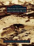
Around Gunnison and Crested Butte
by Crested Butte Mountain Heritage Museum Duane Vandenbusche Gunnison Pioneer MuseumThe Western Slope towns of Gunnison and Crested Butte are defined by their placement in the Colorado Rockies. Both are located in alpine valleys surrounded by 14,000-foot-high peaks with sparkling mountain-fed streams, and both dominate the Gunnison country, a unique wilderness covering over 4,000 square miles. Beginning over 400 years ago, Native Americans, fur traders, explorers, miners, railroaders, and cattlemen all made a place for themselves in the area. Today Gunnison, Crested Butte, and the Gunnison country remain isolated and tranquil. Recreation, tourism, and cattle ranching now reign supreme as Gunnison and Crested Butte attempt to preserve their distinctly Western heritage.
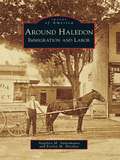
Around Haledon: Immigration and Labor (Images of America)
by Angelica M. Santomauro Evelyn M. HersheyBy 1908, when Haledon became independent from Manchester Township, thousands of southern and eastern European immigrants settled in the borough and its surrounding area. Immigrants found work in textile mills, machine shops, and other industries located in proximity to the city of Paterson and the Passaic River and its mighty Great Falls. Land promoters spurred home building in Haledon, a streetcar suburb. In 1913, nearly 25,000 workers went on strike, demanding an eight-hour workday. During the six-month strike, Haledon became the workers' haven for free speech and assembly as they demanded safer workplaces, a living wage, and an end to child labor. Archival photographs, documents, and postcards from 1890 to 1930 share the story of workers and immigrants who fought for the workplace benefits widely enjoyed by Americans today.
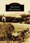
Around Hartwick
by Hartwick Historical SocietyAround Hartwick depicts the history of the rural Hartwick Township at the geographical heart of Otsego County, nestled along the Otego Valley between western hills and the Susquehanna River. Named for John Christopher Hartwick, an itinerant German preacher with the dream of a "New Jerusalem" church and school, the township became the site of the first Lutheran Theological Association in America. Abundant water sources powered large woolen, cotton, and paper mills in Clintonville, Toddsville, and South Hartwick. Fertile land produced farm crops, including a contribution to the highest yield of hops in the world. With extension of the electric trolley north through the Otego Valley to the Mohawk Valley, the Hartwick hamlet prospered as the site of railway headquarters, central carbarns, and the sole power source for this vital transportation link. With the advent of the mechanical age and changing economics, mills relocated, the railway ceased, and farm production declined. Today, the township enjoys renewed prosperity with the influence of history museums and baseball from nearby Cooperstown.
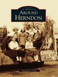
Around Herndon (Images of America)
by Margaret C. PeckThe town of Herndon is situated on the western edge of Virginia's picturesque Fairfax County. In the 18th and early 19th centuries, this part of Fairfax County was primarily agricultural, and as additional settlers arrived farming flourished. Early residents found woods, flat open fields, outcroppings of rocks, and workable soil throughout the region. By 1857, the installation of the railroad line brought summer residents, commuters, and real estate developers to the area. Residential growth continued into the 20th century, as more Washington, D.C. workers chose Herndon as a convenient town from which they could commute to their jobs. From 1959 to 1961, the railroad line experienced busy years when it was used to haul sand and construction materials to build neighboring Dulles Airport, which opened in 1962. Although the region has become a center of Internet technology, with several high tech companies located in the area, Herndon still retains a small-town charm.
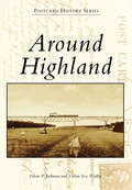
Around Highland (Postcard History Series)
by Ethan P. Jackman Vivian Yess WadlinThe history of Highland began on the shores of the Hudson River in 1754, when entrepreneur Anthony Yelverton started a sawmill, later followed by a brickyard, store, and ferry service to Poughkeepsie. During the 19th century, steamboats made regular stops near Yelverton's settlement. Starting around 1830, riverfront businesses began to relocate to the "high land" above the river, and a new Highland business district was born. The West Shore Railroad was completed in 1883, with a station at the riverfront. The area was called Highland Landing. The Poughkeepsie-Highland Railroad Bridge, now the Walkway Over the Hudson, was completed in 1888, and in 1897, a trolley line began operation from Highland Landing up to the Highland village and, from there, westward. Highland had a new claim to fame as the "Gateway to Ulster County."
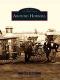
Around Hornell (Images of America)
by Kirk W. HouseAround Hornell tells the tale of western New York's "Maple City" and its neighbors, the rural towns of Canisteo, Dansville, Fremont, Hartsville, Hornellsville, and Howard. The region is set in the dramatic countryside between the Finger Lakes and the Appalachian Mountains, home to the deep gorges of Stony Brook State Park. Great arks floated down the Canisteo River to markets in Baltimore, and for more than a century, Hornell roared with round-the-clock work in the Erie Railroad shops. Hornell is a musical city of community bands, high-school operettas, and barbershop quartets, and its famous residents include radio star and pioneer pilot Blanche Scott, aspiring major leaguer Don Zimmer, and New York's longest-serving mayor, Shawn Hogan, who has graciously provided the introduction to Around Hornell.
Around India in 80 Trains
by Monisha RajeshTaking a page from Jules Verne's classic tale, Monisha Rajesh embarked on an adventure around India in eighty trains. Indian trains carry over twenty million passengers daily, plowing through cities, crawling past villages, climbing up mountains, and skimming along coasts. Monisha hopes that her journeys across India will lift the veil on a country that had become a stranger to her.

Around India in 80 Trains: One of the Independent's Top 10 Books about India
by Monisha Rajesh'Crackles and sparks with life like an exploding box of Diwali fireworks' -William Dalrymple'One can only envy Monisha Rajesh as she embarks on this epic journey' -Tim ParksWhen she was a child, Monisha Rajesh's family uprooted to Madras in the hope of making India their home, but soon returned to England with a bitter taste in their mouths. Two decades on, Monisha turns to a map of the Indian Railways and takes a page out of Jules Verne's classic tale, embarking on an adventure around India in 80 trains, covering 40,000km - the circumference of the Earth.Her journey takes her on toy trains, luxury trains, Mumbai's infamous commuter trains and even a hospital on wheels. Along the way she meets a kaleidoscope of characters and discovers why the railways are considered the lifeline that keeps the country's heart beating. Most of all, she hopes that these 80 train journeys will lift the veil on a country that has become a stranger to her.
Around India in 80 Trains
by Monisha RajeshTaking a page from Jules Verne's classic tale, Monisha Rajesh embarked on an adventure around India in eighty trains. Indian trains carry over twenty million passengers daily, plowing through cities, crawling past villages, climbing up mountains, and skimming along coasts. Monisha hopes that her journeys across India will lift the veil on a country that had become a stranger to her.
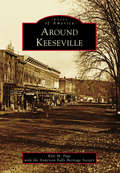
Around Keeseville
by Kyle M. Page Anderson Falls Heritage SocietyNestled in the northernmost section of the Adirondack Mountains, the communities of Keeseville, Port Kent, Ausable Chasm, Clintonville, Harkness, Port Douglas, Ausable, and Chesterfield provided early settlers of the 1800s with a wealth of natural resources in wood, iron, and stone. The Ausable Chasm and Ausable River provided the natural power to refine the materials on-site, while the nearby Lake Champlain provided the transportation to the rest of the world. For early America, this was a booming community that rapidly grew from the 1850s until the 1920s, when modernized transportation and factories around the country made the fairly isolated area less cost-effective. Today, Keeseville is a quiet stop on the Northway that connects New York City and Albany to Montreal. Impressive bridges, closed factories, and some old grand architecture are remnants of the glory days of the once-booming community.
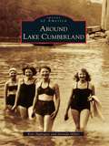
Around Lake Cumberland (Images of America)
by Jarenda Miller Kris ApplegateLake Cumberland is a premier vacation destination for millions of people each year. With its 1,255 miles of federally protected shoreline, an average depth of 90 feet, and a surface area of more than 60,000 acres, Lake Cumberland is one of the largest man-made lakes in the United States, yet visitors may not realize the storied history that lies beneath the deep water. Before Lake Cumberland became a recreational paradise, the wild and wondrous Cumberland River ruled the land. Although plagued by spring floods, towns and communities prospered along her banks. In an effort to control the Cumberland River and reduce flooding, Wolf Creek Dam was constructed following the Flood Control Act of 1938. With the dam in place, Lake Cumberland began filling in 1951. The dam offered protection to South Central Kentucky, but it drowned or forever changed many thriving towns and communities. Images of America: Around Lake Cumberland shows what life was like along the banks of the Cumberland River before Lake Cumberland was born.
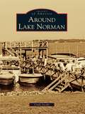
Around Lake Norman (Images of America)
by Cindy JacobsThe year 1957 brought change to Mooresville and southern Iredell County, and that change arrived in trucks. Big white ones flashed the logo of Burlington Industries, the new owners of the Mooresville Cotton Mills. Bright yellow ones from the Duke Power Company brought earth-moving machines to clear the Catawba River bottomland. That project, envisioned by James Buchanan Duke, Dr. Gill Wylie, and William States Lee Jr., had the end goal of harnessing the energy of the Catawba River to provide electricity for the textile industry in the Carolinas. Duke Power's plan for Cowans Ford Lake was the last piece of the network of hydroelectric stations, and the result was beautiful Lake Norman.
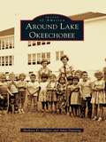
Around Lake Okeechobee
by Barbara D. Oeffner Amie DunningFrom the Calusa Indians to the travelers who used boats for transport in the early 1900s and up to the prosperous farms and cattle ranches of today, the Everglades has evolved into a mecca for fishing, birding, and hiking. The smell of orange blossoms entices the settler to an untamed land where bears, deer, and snakes still inhabit the wilderness and where alligator hunting and fishing are still popular sports. Lake Okeechobee is 110 miles around from Pahokee to Canal Point, Okeechobee, Lakeport, Moore Haven, Clewiston, South Bay, and Belle Glade. To cross Florida from the Atlantic to the Gulf, a boat starts in Stuart and ends at Port Mayaca, crossing Lake Okeechobee to the Moore Haven lock and out the Caloosahatchee River past Lake Hicpochee and west to Fort Myers. Around Lake Okeechobee presents images from the Clewiston Museum, Lawrence E. Will Museum, state archives, and private collections, painting a history of the boom and bust, the boaters and farmers, and the cattlemen and ranchers who have settled and raised their families here.
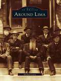
Around Lima
by Michael LeavySome twenty miles south of Rochester lies what was historically the "crossroads of western New York." Lima and its neighbors in the Genesee Valley are unique in many ways. An excellent network of trails had been developed by the Iroquois long before the area attracted its first permanent settler in 1788. As immigrants streamed westward, inns opened at this crossroads to serve them, and some of the travelers stayed to become farmers, tradesmen, and merchants. In the mid-1800s, Lima had several photography studios and a wealth of architectural gems, many of which still remain. Today, Lima has more than fifty structures listed on the National Register of Historic Places.Around Lima explores the fascinating evolution of Lima and the diverse adjoining towns that were inexorably connected. It illuminates the elegant streets of Lima, the rich heritage of nearby Bloomfield, the covered bridge and stone mills of Honeoye Falls, and the grandeur of the resort days of Avon Springs, which rivaled Saratoga Springs. Appearing within these pages are glimpses of Susan B. Anthony and Franklin Delano Roosevelt, as well as accounts of the Underground Railroad and a winter morning's journey to see Abraham Lincoln.
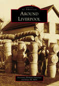
Around Liverpool
by Joyce M. Mills Dorianne Elitharp GutierrezLiverpool, on the shore of Onondaga Lake, was settled by John Danforth and his family due to the natural brine springs near the lakeshore. The population of salt boilers quickly grew. The Oswego Canal opened in 1828, and the village was incorporated in 1830. German immigrants brought willow weaving to the village in the mid-1850s, and by the 1890s, Liverpool willow products were being shipped all over the nation. In the 20th century, as more lucrative work became available and the automobile ruled, the basket weavers gave way to factory workers, nurses, teachers, and engineers. Around Liverpool takes you on a tour of the unique history of Liverpool, with images of its salt boilers, weavers, firefighters, schoolchildren, churchgoers, ice boaters--the people and places that made the community.
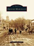
Around Marcellus
by Leslie Church KrausAround Marcellus recounts the rich history of a community founded by strong and determined settlers. Marcellus and its neighbors Otisco and Marietta are located just west of Syracuse. Founded in 1794, the town grew largely because of its successful mills and businesses. Its history from the mid-1800s to the mid-1900s is portrayed here in clear narrative and some 200 archival images from the Marcellus Historical Society.
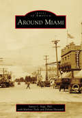
Around Miami
by Marlene Tiede Delvan Hayward Santos C. VegaDuring the late 1800s, prospectors in search of gold, silver, and copper began to settle around the Pinal Mountains area in Miami. By 1918, several mining companies had established roots and contributed to the town's booming growth. The community established housing, schools, a hospital, and a town government, and the population grew to 5,000. Soon, Miami achieved recognition as one of the main mining towns in the state, along with neighboring Globe, Jerome, Morenci, Superior, Ajo, and Ray-Sonora. The new mining opportunities brought immigrants from around the world to settle in the area and eventually turned Arizona into a leading contributor to the copper industry. Although mining's hold on the local economy has changed over the years, today at least 20 percent of Miami-area employment is centered around copper mining, which remains close to the heart of the first hardy miners' descendants.
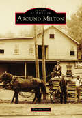
Around Milton
by Timothy StarrThe town of Milton, New York, lies near the center of Saratoga County. It is crisscrossed by a series of rivers, which have played an important role in the town's development--most notably, the Kayaderosseras. Milton's only village, Ballston Spa, with the attraction of its rare mineral springs, was once among the country's most popular tourist destinations. One of the largest and most elegant hotels in the world, the Sans Souci, vied with a host of others for the patronage of thousands of travelers who made the pilgrimage each summer to partake in the "healing waters." When the tourist trade faded, it was replaced by a massive expansion of industry that was situated along the town's waterways. Among the most significant of these concerns were the mills of the "Paper Bag King" George West, Isaiah Blood's ax and scythe works, and the mammoth tannery of Samuel Haight. Today, its proximity to the state capital and other cities makes the town an increasingly popular residential area, complemented by a quaint and bustling business district in Ballston Spa.
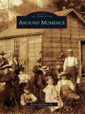
Around Momence
by Kevin Mcnulty Sr.As evidenced by the historic record of Burt E. Burrough's book entitled Tales of an Old Border Town and along the Kankakee (1925), the city of Momence owes its origins to the flow of the Kankakee River through eastern Kankakee County. This diverse tributary linked marshy areas in Indiana to the adjacent fertile fields on the Illinois side. Momence became a beacon, providing traders with the latest conveniences and a break from the frontier. Years later, the historic Dixie Highway crossed the river at Momence, assuring a modern era for the city. In her writings of 1983-1984, the great educator and historian Kay Hess revealed the community spirit, entrepreneurial zeal, and celebratory nature of Momence through the many personalities of this rural city. Today, as Momence approaches its 200th year, massive urban sprawl promises to wash over this ever-changing community and add to its history.
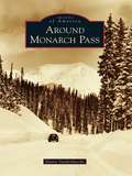
Around Monarch Pass
by Duane VandenbuscheMonarch Country is an incredibly beautiful mountain region spanning both sides of the Continental Divide in the southern portions of Chaffee and Gunnison Counties in the Rocky Mountains of south-central Colorado. Monarch Pass, at 11,312 feet above sea level, divides the Gunnison Country in the west from the Arkansas River watershed in the east. This scenic, wild, and rugged region surrounding the crossroads of U.S. Routes 50 and 285 is rich in mining, railroad, and skiing history and once included booming mining camps such as Maysville, Garfield, Monarch, and White Pine. The crown jewel of this spectacular high-country landscape is the Monarch Ski Area, which enjoys 350 to 500 inches of snowfall every year.
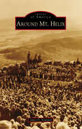
Around Mt. Helix
by James D. NewlandEvery year, the morning of Easter Sunday, thousands of intrepid souls trek to the summit of San Diego County's Mt. Helix. Once there, they experience the nearly century-old tradition of a community-based sunrise service held at the historic Mt. Helix Nature Theater. Constructed for that purpose in 1925, and located in a unique, privately-owned "public" park, the landmark serves as just one of the reasons this conically shaped peak has become a regional, cultural, and natural icon. Named for a rare gastropod, the 1,375-foot-high pinnacle also serves as a geographic beacon for the mostly unincorporated surrounding communities of Mt. Helix, Grossmont, Calavo Gardens, Casa de Oro, Spring Valley, and the adjacent, historically related municipalities of El Cajon, Lemon Grove, and La Mesa. Today, these semirural communities are renowned for their idyllic, family-friendly neighborhoods; classic early-20th-century Revival-style and custom midcentury Modern architecture; and long-standing commercial and civic institutions.
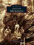
Around Murphys
by Judith MarvinMurphys is a bustling little town in the foothills--a town so popular that it won't be little for long. It's a favorite for weekend jaunts, and home to an eclectic group of people attracted by the natural surroundings, laid-back lifestyle, and, increasingly, world-class wineries. Originally named for the trading camp of John and Daniel Murphy, the area became a boomtown during the Gold Rush, and later hosted such notables as Mark Twain, Black Bart, Ulysses S. Grant, and Horatio Alger. Nearby, the majestic stands of redwood at Calaveras Big Trees State Park stand sentinel over the gullies and ranches of this area, which has changed much since the 1800s but still retains its compelling forested beauty.
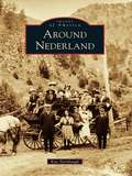
Around Nederland
by Kay TurnbaughNederland survived three boom-and-bust cycles involving three different minerals. During the silver boom, U.S. president Ulysses S. Grant visited Central City in 1873 and walked on silver bricks that had been mined in Caribou and milled in Nederland. The second boom followed the discovery of gold in Eldora in 1897 and lasted only a few years. The third boom was sparked by the discovery of tungsten by Sam Conger, the same man who made the original discovery of silver in Caribou. The Conger mine eventually became the greatest tungsten mine in the world. During World War I, Nederland's population swelled to 3,000--twice the size it is today--and another 2,000 were estimated to live nearby. In each boom, men came to mine, open stores, and transport goods and ore. They brought families with them, and many towns sprang up, including Caribou, Eldora, Lakewood, Tungsten, and Rollinsville. Some of these communities have survived, while others remain only in memories and photographs.
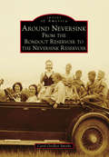
Around Neversink: From the Rondout Reservoir to the Neversink Reservoir
by Carol G. SmytheAround Neversink: From the Rondout Reservoir to the Neversink Reservoir takes readers back to rural life in the Catskill Mountains not long after its first settlers arrived. Before the land was commissioned to provide water for New York City's nine million residents, the area was known for some of the best trout fishing in the world. Red Hill, Peekamoose, Sundown, Branch, Frost Valley, Dewittville, Halls Mills, Willowemoc, Grahamsville, and Claryville were small communities mostly clustered around the banks of the headwaters of the Neversink River or the Rondout Creek. The area became a summer destination, and local farmhouses were converted into boardinghouses to accommodate seasonal travelers. In the 1900s, eminent domain took several communities to create the Rondout Reservoir and the Neversink Reservoir. As a result, Neversink Flats, Bittersweet, Eureka, Montela, and Lackawack ceased to exist. Today, residents and visitors enjoy a host of outdoor activities, including hiking on local mountains, snowmobiling on well-groomed trails, fishing in the reservoirs, bird watching, camping, and hunting.
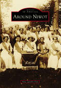
Around Niwot (Images of America)
by Anne Quinby DyniBy the time the Colorado Central Railroad extended its tracks into Boulder County in 1873, much of the land along the foothills was already under cultivation. As rails were laid between Boulder City and Longmont to the northeast, they crossed land belonging to settlers who had first come to the region as prospectors with the Pikes Peak Gold Rush of 1858. At that time, the area was still the hunting and fishing grounds of Southern Arapaho Indians and their tribal leader, Chief Niwot, translated as "left hand" in the Arapaho language. Two ranchers, Porter Hinman and Ambrose Murray, whose land was traversed by the new railroad, platted the town of Niwot in 1875 as a shipping point for transporting local farm goods and livestock to distant markets. Thus the only authentic railroad town in Boulder County was founded.