- Table View
- List View
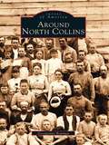
Around North Collins
by Georgianne BowmanSouthern Erie County, around North Collins, was originally inhabited by the Seneca Nation of Native Americans. Beginning in the late 1790s, English Quakers moving west from New England arrived, and as the 1800s progressed, waves of German and Italian immigrants followed, seeking political and economic stability. Later, immigrants of other nationalities settled in the area, adding their contributions to this area of rich diversity.Around North Collins contains a unique combination of vintage photographs and historical knowledge on North Collins and fourteen other communities: Shirley, Langford, Clarksburg, New Oregon, Marshfield, Collins Center, Collins, Gowanda, Lawtons Station, Brant, Farnham, Angola, Pontiac, and Kerr's Corners. The photographs, many of which have never before been published, come from the collections of local historians, historical societies, and area families. Pictured are people at home, at school, at ceremonies, and at work, using the tools of their craft.
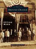
Around Orange
by Robert J. TuholskiLocated between the Quabbin Reservoir and the New Hampshire state line, Orange has developed from a sparsely-settled, agrarian countryside to a thriving industrial community along the banks of the Millers River. Around Orange includes images of this town and the surrounding towns of Athol, Erving, New Salem, Warwick, and Wendell. Through photographs, postcards, and stereoview cards from a bygone era, this volume provides a glimpse of what it was like to live and work in this area long ago. Seen here are vintage images of schools, churches, public buildings, homes, businesses, industries, celebrations, and disasters.
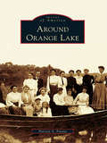
Around Orange Lake (Images of America)
by Patricia A. FavataAround Orange Lake portrays the history of the lake and the adjoining locales of Gardnertown and Meadow Hill. The only natural lake for miles, Orange Lake was the location of a Colonial coinage mill, a source of power for many early industrial ventures, and home to one of the East Coast's most famous amusement parks. In the late 1800s, cabins began to dot its shores, and by the 1920s, bungalow colonies flourished, with cottages that today have become substantial year-round homes. The lake also hosted famous personalities, including a Boston Tea Party participant, an early pilot, and a former governor. Their stories and others are intertwined with the history of the lake to create a picture of a very unique community.
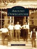
Around Oswegatchie (Images of America)
by David E. MartinAround Oswegatchie provides a vivid look at the lifestyle of an area of far northern New York State during the time that it depended primarily on an agrarian existence. In its early days, the town of Oswegatchie was subdivided numerous times into new townships. From Oswegatchie, Lisbon, Morristown, and DePeyster came artists, politicians, industrialists, inventors, and Civil War heroes-- people who left their footprints on a nation and helped make a better life for all.
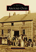
Around Ovid (Images of America)
by Ovid Historical SocietyOn land freed from American Indians upon the orders of George Washington, the town of Ovid was formed in 1794, after military lots were numbered by Simeon DeWitt and his assistants. In 1860, construction was completed on three brick buildings that became known as the Three Bears, which served as the town's courthouse, eventually served as the Seneca County Seat, and now serve as the Town of Ovid municipal offices. Gradually, more settlers came, cleared land, built roads, started businesses, and founded churches and schools. Bordered by the Seneca and Cayuga Lakes, where barges were used to transport goods, the town developed a vibrant farming community with productive orchards and vineyards. Tourism flourished, and summer homes were built by those looking to escape the city. One of these summer homes was that of Herman Westinghouse, who worked together with his brother George Westinghouse on their company's myriad inventions.
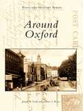
Around Oxford
by Joseph A. Lordi Dolores I. RoweAround Oxford features vintage postcards and photographs from Oxford and the surrounding area, including Lincoln University--the oldest African American institution of higher learning in America--and Nottingham. With the arrival of the Philadelphia-to-Baltimore railroad in 1860, Oxford began to grow and prosper. Because the area is one of the most fertile regions of Pennsylvania, it became a major agricultural center. Along with carriage and candy making, the surrounding area produced important industries, including chrome and magnesium mining, pottery making, and the quarrying of limestone.
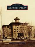
Around Perry
by Christina B. NolanFertile land, waterpower, energetic residents, and a sea serpent all contributed to the growth of the town and village of Perry. The town of Perry was first settled in 1807, and later took the name of Commodore Oliver Hazard Perry, the hero of the War of 1812. Early mills along Silver Creek provided materials for the growing village, which was incorporated in 1830. Perry made headlines in 1855, when a sea serpent was sighted on Silver Lake and people flocked to the area. The mystery went unsolved until remains of the hoax were found in the ashes of the Walker House in 1857. Perry continued to grow, with Main Street businesses changing with the needs of residents. Later industries replaced the early mills, and immigrants arrived to work in the textile factories. Educational, religious, and civic buildings were added to the community, and farms grew in the countryside.
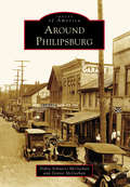
Around Philipsburg (Images of America)
by Dennis Mcgeehan Debra Schnarrs McgeehanPhilipsburg is a community on the Moshannon Creek, which flows east off the Allegheny Mountains in central Pennsylvania. The region was blessed with rich seams of bituminous coal that have provided the area with employment and prosperity. With interests in Philadelphia, the Philips brothers of England founded a colony in the wilds of frontier Pennsylvania in 1797. A gristmill, sawmill, iron forge, and screw factory began the taming of the wilderness. The Philips brothers eventually returned to England over political differences, but the town they founded carried on. Coal, timber, clay, railroads, and metal fabrication have created a community intensely proud of its history. Prone to flooding, the Moshannon Creek divides Centre and Clearfield Counties. This collection of photographs includes communities on both sides of the creek, highlighting the area's people, industry, commerce, architecture, and famous visitors to the town.
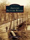
Around Picture Rocks (Images of America)
by Sherry A. GardnerWhen the Sprout and Burrows families purchased what became Picture Rocks for $2,500 in October 1848, the land was considered worthless. The town consisted of a single house and a sawmill that sat at the bend of Muncy Creek. The mill produced window sashes and doors that were in demand for new homes being built in the West Branch Valley. In 1856, S. H. Burrows began manufacturing furniture. Then in the early 1850s, a chapel was built in eight days so that the Baptist community had a place to worship. Around Picture Rocks documents the evolution of this section of Lycoming County. Among the many original structures featured in the book is part of the old Handle and Excelsior building that still greets visitors as they cross the Muncy Creek.
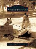
Around Pittsford (Images of America)
by Peggy Armitage Pittsford Historical Society Inc.Winding north through Pittsford, Otter Creek has powered the lumber, grain, and marble mills essential to this region since 1770. Chittenden lies east of Pittsford, on the west flank of the Green Mountains, where iron and manganese deposits supplied Pittsford's iron industry. To the south, Pittsford and Proctor share deep marble formations that support the economies of both towns. The first settlers were farmers drawn to the valley's fertile soil and mountain forests. They were joined by lumber barons, lawyers, merchants, and artists. European and French Canadian immigrants soon followed and farmed, built the railroad, or quarried and carved marble. Closely linked by the industries that helped build them, these communities have evolved into today's thriving hometowns of workers in Rutland.
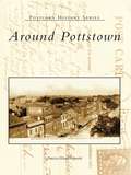
Around Pottstown
by Patricia Wanger SmithAround Pottstown travels back to Pottstown's golden era. Since its founding in 1752, Pottstown has had a catalytic effect on the surrounding area with its industrial and commercial growth during the nineteenth and twentieth centuries. The horse and wagon gave way to new transportation methods, such as canal boats, railroads, and bridges, which afforded connections to the world market. Most importantly, this collection of vintage postcards shows Pottstown's citizens through the places where they shopped, went to school, worshiped, and celebrated life.

Around Randolph Township and Guys Mills
by Cheryl Seber WeiderspahnThe first frontier settlement in what is now Randolph Township took place in 1795 when a handful of brave pioneers overcame incredible odds to settle in the Pennsylvania wilderness. Slowly Randolph became dotted with small clearings, followed by self-sufficient farms. Ambitious tradesmen sold services, and scores of businesses sprouted up. Schools and churches followed as the crossroads of Guys Mills, Black Ash, Mount Hope, Brawley Stand, and Hickory Corners flourished, attracting men of influence. Rev. Timothy Alden, founder of Allegheny College, was pastor of Guys Mills Congregational Church. Famed abolitionist John Brown walked six miles to church in Guys Mills. During the great oil boom, John D. Rockefeller investigated the town's oil wells. Pennsylvania senator Raymond E. Smith resided here. Black Ash's Clint Brown enjoyed a 15-year major-league pitching career with the Cleveland Indians and Chicago White Sox and held a major-league record.
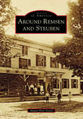
Around Remsen and Steuben (Images of America)
by Megan Plete PostolThe first settlers of the rugged wilderness that became the towns of Remsen and Steuben were hearty pioneers, Welsh immigrants, and a famous Revolutionary War hero. The untamed forest of Oneida County proved challenging but not insurmountable for Remsen’s first settler Barnabas Mitchell and the noble Friedrich Wilhelm August Heinrich Ferdinand Steuben, who was famed with being the sturdy backbone of Washington’s Continental Army and known as the “Drillmaster of the Revolution.” The area flourished into a place of farming, manufacturing, business, and religion. Settlers ranged from rollicking woodsmen to large working families to pious pastors. There were so many churches that the lands of Steuben became known as “the singing hills.” It has been said that the courage of a Welshman rises in proportion to the obstacles thrown in his path. This book strives to tell their tales through visuals of old Remsen and Steuben.
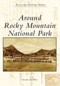
Around Rocky Mountain National Park
by Suzanne SilverthornFollowing the establishment of Rocky Mountain National Park in 1915, promotional campaigns generated by the railroads lured wealthy travelers to the park with images of the great outdoors and the many luxuries offered by the finest hotels. Postcards were circulated proclaiming the park as the "Playground of the World." The gateway communities of Estes Park and Grand Lake became vibrant hospitality centers, and in 1920, when the two towns were connected with the opening of Fall River Road, a new era of tourism was introduced that continues today. More than 200 postcards are used in this book to provide a chronology of the early hotels, ranches, and other settings that have shaped the park's history for more than a century.
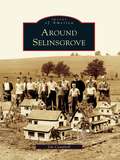
Around Selinsgrove (Images of America)
by Jim CampbellWhile Selinsgrove is typical of the many towns located along the shores of the Susquehanna River, it has cultivated its own identity as the home of Susquehanna University, founded in 1858 as the Missionary Institute and later becoming one of the nation's first coeducational colleges. Prior to the Pennsylvania Canal, several Selinsgrove mills were vital in the worldwide flour trade, where wheat was ground into flour and floated on arks downriver to Baltimore. For most of the 20th century, Rolling Green Park was a leading recreational attraction, and for over 60 years the Selinsgrove Speedway's sprint car races have caused spectators to hail it as "the fastest half-mile dirt track in the East." What truly makes Selinsgrove and the surrounding area prominent is the unique individuals that have marked its history. Through more than 200 photographs, many previously unpublished, Around Selinsgrove depicts the places and people who have made these communities into what they are today.
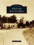
Around South Hill
by John Caknipe Jr.South Hill was formerly located on the old Buckhorn Road near the Meherrin River. It was the site of the first chartered school in Mecklenburg County in 1814. When the founder/teacher/minister/postmaster died in 1857, many from the community relocated 3 miles east to the Boydton-Petersburg Plank Toll Road. In 1888, W. W. "Buck" Harris, a local wheelwright and landowner at Piney Pond and Plank Road, died. At auction, 55 acres of his property were purchased, platted, and parceled for sale by A. E. Batemen and Charles Peck to establish a new South Hill community, which surrounded the Atlantic-Danville Railroad depot. Following this, South Hill became known as the town of highways. With each new highway came significant changes for the town and county.
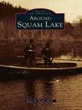
Around Squam Lake (Images of America)
by Bruce D. HealdLocated in the foothills of the White Mountains, Squam Lake was not discovered by English settlers until the mid-1700s. However, the lake area had long been inhabited by the Abenaki Nation of the Algonquin Federation. These people called the waters Kees-ee-hunk-nip-ee, meaning "goose lake in the highlands" (later shortened to Kusumpy or Casumpa) and also Asquam, meaning "water." The latter name was eventually shortened to become Squam Lake. With more than two hundred rare images, Around Squam Lake celebrates the beauty, the geology, and the history of Squam Valley. The book includes early Native American lore and the gradual development of what are known as the Five Towns-namely, Moultonboro, Sandwich, Holderness, Center Harbor, and Ashland. It reflects upon "big" Squam Lake and Little Squam Lake (where On Golden Pond was filmed), highlighting the shoreline points and coves, the succession of islands that dot the surface, and the surrounding mountains, which include the Squam Mountain range, the Sandwich range, and Red Hill, which rises at the head of the valley.
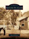
Around St. Clair
by St. Clair Community and Historical SocietySt. Clair lies in a narrow valley rich with anthracite resources. The town was born around 1831, during the great hard coal boom in northeast Pennsylvania. Over the years the town expanded to surrounding areas or patches known as Arnouts Addition, Wadesville, Dark Water, New Castle, Mount Laffee, Crow Hollow, Ravensdale, Lorraine, Diener's Hill, East Mines, and Mill Creek. People came from these areas to work in the mines, railroads, and supporting industries. As the demand for coal increased, the town grew to a high point of 7,000 residents. The decline of the coal industry also brought the decline of the railroads, and the population of St. Clair fell. The photographs in Around St. Clair show the fortitude of its people; the notable residents who have gained national acclaim for their achievements in the labor movement, medical field, and professional sports; and the diverse cultures that make up the town.
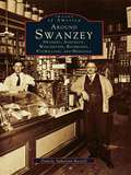
Around Swanzey: Swanzey, Ashuelot, Winchester, Richmond, Fitzwilliam, and Hinsdale (Images of America)
by Pamela Apkarian-RussellNestled against the Massachusetts and Vermont borders are six New Hampshire communities largely unconnected with the rest of their home state. The picturesque bedroom and summer vacation communities of Swanzey, Ashuelot, Winchester, Richmond, Fitzwilliam, and Hinsdale all developed from industrial or agricultural economies, although this fact is less than apparent today. The factories have nearly all vanished, and so has the extreme wealth and glamorous lifestyle of former residents like playwright Denman Thompson. Routes 10 and 12 are still the main roads that connect these towns, however, and the Ashuelot River is slowly recovering from years of pollution in a return to its pure and natural state. In fact, the area's Old Homestead persona seems to have experienced a revival in recent years in the absence of major industry, and it becomes more and more important for residents and tourists alike to be reminded of the area's nineteenth-century economic development.
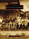
Around Sylvan Beach (Images of America)
by Brandy AnnOn the sandy shores and calm waters of Oneida Lake rests Sylvan Beach. For many years, the entire region was simply known as Fish Creek, and it was settled by George Haskins in the early 1800s. When the Erie Canal was completed in 1825, the area began to flourish. James D. Spencer arrived in the hamlet of Fish Creek in the 1840s and settled near Wood River and the Oswego Midland Railroad station. In the 1870s, he began to develop the sandy shores along Oneida Lake, and the first visitors to Spencer's Grove arrived in August 1878. Sylvan Beach received its name in the spring of 1886, when the New York, Ontario and Western Railroad built a loop into Spencer's Grove. Sylvan Beach continued to thrive with the addition of the railway station, allowing the shipment of produce and lumber as well as the arrival of large numbers of vacationers. These vintage images chronicle the history of Sylvan Beach and its surrounding communities, illustrating the region's strong link to the vast history of America.
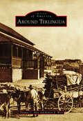
Around Terlingua
by Robert E. Wirt Thomas C. AlexThe origin of the name "Terlingua" is obscure and lost in time. For the past century and a half, the area covered by the name has expanded to include numerous concentrations of people engaged to varying degrees in ranching, farming, and mining, or the support thereof. Farmers and ranchers produced agricultural products, woodcutters supplied timbers for the mines or fuel for the furnaces, and storekeepers supplied the goods needed for sustenance of this diverse community that was spread over much of south Brewster County in West Texas. Hispanic people who began settling the region in the 18th century were the backbone of the mining industry. Many of the families here today are descendants of the mine workers and continue contributing to the community. This story tells of the establishment and abandonment of Terlingua following the rise and decline in demand for mercury and how the ghost town was resurrected in the 20th century.

Around the Bloc: My Life in Moscow, Beijing, and Havana
by Stephanie Elizondo GriestDesperate to escape South Texas, Stephanie Elizondo Griest dreamed of becoming a foreign correspondent. So she headed to Russia looking for some excitement-- commencing what would become a four-year, twelve-nation Communist bloc tour that shattered her preconceived notions of the "Evil Empire." In Around the Bloc, Griest relates her experiences as a volunteer at a children's shelter in Moscow, a propaganda polisher at the office of the Chinese Communist Party's English-language mouthpiece in Beijing, and a belly dancer among the rumba queens of Havana. She falls in love with an ex-soldier who narrowly avoided radiation cleanup duties at Chernobyl, hangs out with Cuban hip-hop artists, and comes to difficult realizations about the meaning of democracy.
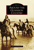
Around the Gunnison Country (Images of America)
by Duane VandenbuscheThe Gunnison country, 4,000 square miles of high valleys, heavy snows, deep canyons, and 14,000-foot-high mountains, is one of Colorado's most beautiful regions. Located on the Western Slope of Colorado, the Gunnison country has a long history involving Native Americans, mining, narrow-gauge railroads, ranching, Western State Colorado University, and recreation. The region has also been influenced by nearby Lake City in the San Juan Mountains, Aspen in the Elk Mountains, and towns on the east side of the famed and historic Alpine Railroad Tunnel. Today, the Gunnison country still is beautiful and tranquil, hosting nearly 2,000,000 visitors yearly while remaining much the same as it was over 125 years ago.

Around the Province in 88 Days: One Woman, Two Pairs of Sneakers and 3000 Kilometers of Nova Scotia Coastline
by Emily Taylor SmithA Nova Scotia woman shares her experience of walking the province&’s coastline for charity and what she learned along the way.Early on a May morning, a young Nova Scotia woman straps on a small backpack and leaves the Halifax Common to start her journey along the coastal roads of Nova Scotia. Planning to cover almost a marathon a day, she will walk the perimeter of the entire province in just under three months to raise awareness for the Heart and Stroke Foundation and the Brigadoon Children&’s Camp Society. She billets with locals each night and meets countless Nova Scotians who come out to walk with her, support her project, and tell their stories. Along the way, fellow walkers share family folklore, tales of buried gold, lost fingers, and detailed instructions on how to catch a beaver by the tail. &“We don&’t wear make-up and we don&’t dust,&” explains one of the women Emily meets near Sable River, when asked how she found the time to rebuild the trails in her area and win the Community Spirit Award. Struggling with blisters, fatigue, and an encounter with a bear cub, Emily walks on, overwhelmed by the generosity of her hosts in each community and by the stunning coastal views at every turn. Around the Province in 88 Days details Emily&’s beautiful and quirky experiences on the road as she develops an intimate connection with the province and its people, unsuspecting of the vast changes the trip will eventually set in motion in her own life.
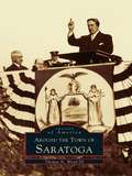
Around the Town of Saratoga
by Thomas N. Wood IIIAs the American struggle for independence intensified, Saratoga became a focal point of warring activities. Both colonists and loyalists maintained forts, camps, and officer headquarters within town. In 1777, after the two Battles of Saratoga, American forces gained the surrender of BritishGen. John Burgoyne, thus turning the tide of the Revolutionary War. The name Saratoga comes from the Mohawk word meaning either "place of the swift water" or "hillside country of the great river." True to its name, the town spreads across rolling hills along the western side of the Hudson River. The river itself, together with two early main roads and a canal, brought prosperity to the area. Saratoga became a major shipping terminal. The town boundaries changed several times throughout the years, but the rural character of the town and the spirit of its residents remained constant.